


by Daniele Bailo and Manuela Sbarra
The European Plate Observing System (EPOS) aims at creating a pan-European infrastructure for solid Earth science to support a safe and sustainable society. In accordance with this scientific vision, the mission of EPOS is to integrate the diverse and advanced European Research Infrastructures for solid Earth science relying on new e-science opportunities to monitor and unravel the dynamic and complex Earth system.
The EPOS architecture [L1] is composed of three connected technical and organisational layers (Figure 1):
- National research infrastructures (NRI)
- Thematic core services (TCS)
- Integrated core services (ICS).
Multidisciplinary data and data products are organised and governed by the thematic core services (TCS) and are driven by various scientific communities encompassing a wide spectrum of Earth science disciplines (e.g., EIDA/ORFEUS in seismology [L3]). Such communities rely in turn on data provided at a national level by national research infrastructures (NRIs).
TCS data, data products, services and software will be integrated into integrated core services (ICS), a platform that will ensure their interoperability and access to these services by the scientific community and other users.
From the above organisational architecture, it is quite clear that EPOS integrated core services are an example of a virtual research environment (VRE). EPOS ICS is indeed currently one of the use cases that will take advantage of architecture paradigm developed by the VRE4EIC project [L2] at the implementation stage.
An architectural model was developed in VRE4EIC, following a rigorous method that started from the use cases, elicited the requirements, listed the system functionalities and finally developed an abstract architecture on the basis of the functionalities. The architecture is based on a modular paradigm, and the functionalities are implemented by a number of core components. In order to validate the VRE4EIC components, EPOS has been selected as one of the use cases to demonstrate the robustness and scalability of the VRE4EIC model.
In the framework of EPOS ICS implementation, one of the main components is the metadata manager. As described elsewhere [1], metadata is the main concept over which the whole EPOS VRE – in agreement with the VRE4EIC model – builds upon. The metadata manager, implemented as a metadata catalog, contains all the information that the system needs to manage in order to satisfy a user request. It contains the descriptions in a digital representation of the EPOS e-Infrastructure, including data, software, users and resources such as computers, detectors or laboratory equipment. As recommended by VRE4EIC, it uses CERIF [L4] as a tool to harmonise information on research. CERIF describes datasets but also software, services, users and resources such as computers, datastores, laboratory equipment and instruments and has already been used in the context of environmental sciences [2].
Another key component of EPOS implementation is the interoperability layer (Figure 1). This layer contains all the sub-components (mappers, convertors etc.) devoted to the communication with the national research infrastructure. One of its main functions is metadata exchange: metadata from data providers should be harvested by the ICS main system (the VRE). It requires the construction of mappers, to map the community specific metadata to CERIF, and convertors. When the metadata cannot be harvested, as in the case of provision of service based systems (e.g., web mapping services that provide access to geological maps), the web services need to be mapped in order to enable the VRE to broker the access to data. This layer also includes all the semantic mapping, which is currently one of the greatest challenges to tackle. Examples of mapping from most known metadata ISO standards have been studied and implemented in the EPOS VRE [3] and in other contexts [2]. Mappings from one metadata standard to another are currently under development in VRE4EIC in the framework of WP4 with a dedicated tool, namely the ‘3M’ (mapping memory manager) [L6] developed by ICS-FORTH.
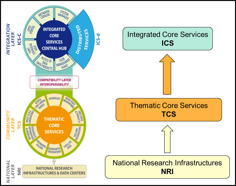
Figure 1: Key elements of the EPOS Functional Architecture.
Other components in the EPOS ICS system include: (a) an AAAI (Authentication, Authorisation, Accounting Infrastructure) module [L5], dedicated to the secure authentication and authorisation of users also with different authentication systems (SAML, OAuth, OpenID, X.509 and related products such as EduGAIN, Shibboleth, Kerberos and others); (b) a system manager and a workflow engine, that manage the user request, establish the list of actions to be executed, execute the workflow and assemble the output.
In this context, VRE4EIC is providing the above architectural framework, together with state-of-the-art methods and best practices, to enable any research infrastructure to get to the level of a virtual research environment. Virtual research environments enhance the functionalities of the research infrastructures, that usually provide access to domain specific data, by widening the level of integrated information available to the user. In the case of EPOS, information about specific data, together with usage computational services and tutorial, training and other types of documentation that can enable any citizen scientist to have knowledge about solid Earth processes, will be available.
The innovation impact of the VRE4EIC architecture – based on metadata brokered paradigms – is enormous and not yet fully exploited, especially in the environmental data domain, where the integration of different types of data (e.g., seismic, geological, geodetical) together with computational tool and remote collaborative tools, can help to monitor and unravel the dynamics and the complexity of the Earth system.
Importantly, the use and re-use of data and the harmonised access to services that the creation of VREs can enable, will foster the creation of new scientific data products, which can be made accessible through the same EPOS VRE platform. The potential impact of this new scientific delivery system for environmental sciences and for the society is still unexplored.
Links:
[L1] https://epos-ip.org/
[L2] http://www.vre4eic.eu
[L3] http://www.orfeus-eu.org/
[L4] http://www.eurocris.org/cerif/main-features-cerif
[L5] https://epos-ip.org/glossary/aaai
[L6] http://139.91.183.3/3M/
References:
[1] K. Jeffery, D. Bailo: “EPOS: Using Metadata in Geoscience. Metadata and Semantics Research, 170–184, 204, http://link.springer.com/chapter/10.1007/978-3-319-13674-5_17
[2] E. Boldrini, et al.: “Integrating CERIF Entities in a Multidisciplinary e-infrastructure for Environmental Research Data”, Procedia Computer Science 2014 vol: 33 pp: 183-190.
[3] D. Bailo, et al.: “Mapping solid earth Data and Research Infrastructures to CERIF”, 0, 9–11, 2016, http://dspacecris.eurocris.org/handle/11366/537
Please contact:
Daniele Bailo
EPOS Management Office ICT – INGV, Italy
+39 06-51860728,

