


by Petros Patias (KIKLO), Charalampos Georgiadis (AUTH), Patrick Bourdot (EuroXR)
The SURE-VFT project aspires to harness XR technologies for inclusive and accessible training in photogrammetry, 3D modelling, and remote sensing based on training provided through virtual field trips (VFTs) available through the XR4ED education platform [L1]. The project aims to lower barriers of geography, cost, mobility, and access to equipment—contributing to more equitable opportunities for hands-on education.
The SURE-VFT project (Immersive Exploration and Data Acquisition: XR Virtual Field Trips for 3D Photogrammetry and Remote Sensing) [L2, L3] introduces an innovative way to deliver surveying education through immersive technology. Funded indirectly by the EU’s Horizon Europe programme via the XR4ED Open Call, the project harnesses Extended Reality (XR) to simulate real-world surveying conditions, offering students practical, hands-on training in an inclusive and flexible way. The pilot implementation is now underway, representing a major step toward scalable, responsible digital innovation in higher education.
Led by KIKLO with key participation from the Aristotle University of Thessaloniki (AUTH) and EuroXR, the project combines academic insight, software development, and XR community engagement. Three interactive Virtual Field Trips (VFTs) were designed:
- Close-range photogrammetry;
- Spectroradiometer usage and spectral signature interpretation;
- Land Use/Land Cover (LULC) mapping using remote sensing data.
Each VFT aims to replace or complement traditional fieldwork, addressing inclusion and accessibility through a simulated learning experience that mirrors real-life conditions. The VFT design procedures were based on co-design principles, actively involving students, tutors, and industry professionals to ensure accessibility and usability. The primary feedback collection tool was a large-scale web-based questionnaire in order to reach a large number of stakeholders efficiently. Key messages stemming from these user requirements include the need to provide the VFTs through an easily accessible process, to consider a mix of guided and exploratory learning, with a preference for functional realism rather than hyper-realism. In terms of device preference, desktop PCs/laptops and mobile devices were strongly preferred, indicating the importance of accessibility and versatility, while XR headsets were less preferred. This development process underscores the project’s alignment with responsible innovation, as choices were driven not only by available technology but also by stakeholder needs and equity concerns.
The three SURE-VFT applications rely on Portal Hopper [L4] and World Builder. These two distinct, yet interconnected tools are provided by Portals United, forming the foundation of the XR4ED platform, which also hosts the SURE-VFT project. The SURE-VFT XR applications are available through the XR4ED platform marketplace. The XR4ED marketplace acts as a central, open-access hub where users can browse, select, and download immersive educational applications (VFTs), ensuring equitable dissemination across institutions and countries.
Field training is an essential part of surveying engineering education—but it is often constrained by costs, weather, equipment access, or geography [1]. By contrast, the SURE-VFT applications allow students—regardless of their physical location or personal circumstances—to practice core tasks remotely. This is critical for learners who might otherwise be excluded, such as those with mobility impairments, financial constraints, or limited institutional resources. The COVID-19 pandemic further highlighted the need for digital alternatives to hands-on learning. SURE-VFT responds to these challenges by enabling students to experience data collection, image analysis, and field protocols through their computers or VR devices—regardless of physical location.
Beyond convenience, XR technologies have been shown to improve engagement, motivation, and knowledge retention compared to traditional instruction [2]. The project specifically targets novice users with limited prior experience in either surveying instruments or XR platforms. Through step-by-step workflows, real-time feedback, interactive learning modules, and built-in support, students can practice key tasks like positioning cameras, selecting ground control points, analysing spectral data, and classifying land cover-—all within a controlled virtual setting.
Each scenario follows a consistent workflow: from registration and application download to in-environment task completion and final feedback submission. For example, in the photogrammetry VFT, users navigate around a virtual observatory as shown in Figure 1, identify ground control points, and evaluate photo quality for 3D reconstruction. In the LULC scenario, students interpret satellite imagery and classify land cover based on image interpretation principles. Each scenario ends with an integrated questionnaire to gather detailed feedback targeting different stakeholder groups—students, educators, and administrators. These tools gather both quantitative and qualitative data on usability, clarity, realism, and perceived learning value. Preliminary responses have shown high satisfaction, with over 60% of participants agreeing or strongly agreeing that the XR experience helped them better understand complex surveying concepts.
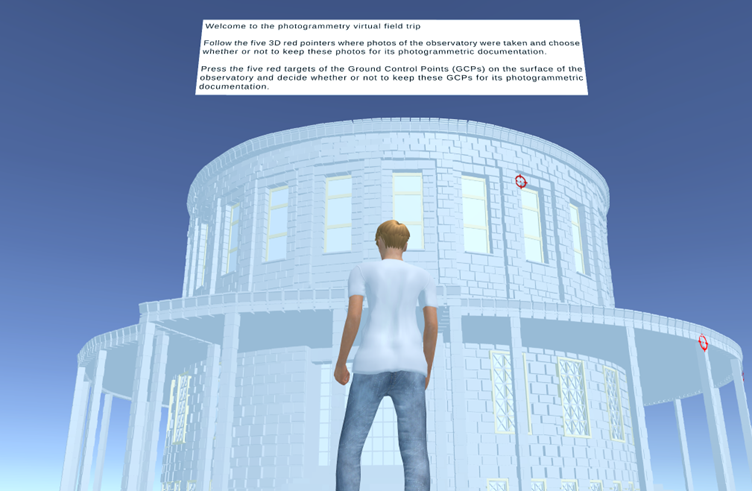
Figure 1: Virtual scene depicting the observatory of the Aristotle University of Thessaloniki within the close-range photogrammetry virtual field trip.
In addition to user feedback, the platform tracks key performance indicators (KPIs) such as VFT apps downloads, task completion rates, and dataset access. These analytics will be used to refine future VFT content and support decision-making for scaling the solution.
All three VFTs are accessible via desktop PC/laptop, supporting different hardware setups and user preferences. Based on early feedback, most students prefer using personal computers for their XR training—highlighting the importance of user-friendliness and accessibility in XR tool design.
By lowering barriers to field training, SURE-VFT makes surveying education more resilient to disruptions (e.g., pandemics) and more inclusive of diverse learners. SURE-VFT also expands access through inclusive digital futures, modernising surveying engineering education and preparing a generation of students to work confidently in digital and hybrid environments.
The SURE-VFT project has indirectly received funding from the European Union’s Horizon Europe research and innovation action programme, via the XR4ED – Open Call issued and executed under the XR4ED project (Grant Agreement no. 101093159).
Links:
[L1] https://xr4ed.cellock.com
[L2] https://www.euroxr.org/sure-vft-xr4ed
[L3] https://sure-vft.eu/
[L4] https://www.portalhopper.com/xr4ed/
References:
[1] D. Bolkas, M. O’Banion, E.I. Parisi, P. Bauer, I. Detchev, “Demonstration of Immersive Technologies for Geospatial Learning,” ISPRS Annals of the Photogrammetry, Remote Sensing and Spatial Information Sciences, 2024; X-5:1–7. https://doi.org/10.5194/isprs-annals-X-5-2024-1-2024
[2] E. Pérez-Martín, S. López-Cuervo Medina, T.R. Herrero-Tejedor, A. Ezquerra-Canalejo, D. López-Fernández, “Using Virtual Reality in the Learning of Geomatic Engineering Education,” IEEE Computer Graphics and Applications, 2024; 44(6):77–88. https://doi.org/10.1109/MCG.2024.3507284
Please contact:
Petros Patias, KIKLO – Geospatial Information Technologies P.C., Thessaloniki, Greece
Charalampos Georgiadis
The Aristotle University of Thessaloniki, Greece