by Andrea Siposova, Rudolf Mayer (SBA Research), Matthias Schlögl (GeoSphere Austria) and Jasmin Lampert (AIT)
Climate change brings about changes in both frequency and intensity of extreme weather events around the globe, with impacts on mountain areas such as the Austrian Alps being particularly severe. Conditions conducive to natural hazards such as landslides are expected to increase. The potential damage resulting from such gravitational mass movements underscores the importance of strengthening knowledge about the likelihood of their occurrence. Within the Austrian project gAia, funded by KIRAS [L1], we develop a data-driven approach to provide stakeholders with actionable knowledge to increase preparedness, aid decision-making and support adaptation measures for making our society more climate resilient.
While climate change impacts manifest on a global scale, the European Alps are seriously affected as well, with glacier retreat and permafrost thaw already constituting tangible ramifications [L2]. In addition, changes in precipitation patterns, most notably increases in rainfall intensity and duration, will affect the occurrence of gravitational mass movements [1]. This is particularly the case for process types that are triggered by heavy rainfall, such as shallow landslides.
Gravitational natural hazards pose a safety risk to people and can potentially cause extensive damage to infrastructure [2]. Consequently, knowledge about the likelihood of their occurrence is of great importance for proactive spatial planning, effective mitigation and adaptation measures, as well as disaster risk reduction in general. Landslide susceptibility models estimating the probability of landslide occurrence are a powerful tool for generating landslide hazard maps. However, as with any machine learning model, their performance depends on the quality of the training data and labels, and thus on representative inventories of observed landslides. Despite efforts to record historic events, currently existing inventories are incomplete or imprecise regarding, for example, the time of a landslide occurrence, the exact area, event magnitude or process type. Moreover, there is a lack of a holistic approach that would take qualitative and multimodal aspects of data fusion into account. Reliable methods are therefore needed for automatically detecting landslides or circumstances that may lead to landslides. Machine learning techniques offer a standardised and efficient approach to complement and validate existing inventories.
Within gAia [L3], we aim at combining the two approaches to provide stakeholders with actionable knowledge to support resilience strategies with respect to allocating resources, setting priorities for spatial planning or assessing environmental impacts.
Detection
Existing inventories are supplemented by landslide occurrences detected via remote sensing methods. In addition to geographic object-based image analysis for detecting and delineating landslides in very high-resolution digital terrain models (DTM), we use Copernicus Sentinel-2 images within the gAia project. Changes in vegetation between two sensing dates serve as a proxy for landslides. The normalised difference vegetation index (NDVI), which is derived from the near-infrared and visible red spectral bands of Sentinel-2 images, is employed to capture this information. Subsequently, for each pair of images, neighbourhood correlation images (NCI) are computed. By incorporating pixel neighbourhood information, we aim to improve the detection of landslides performed using the calculated index only. The newly computed images allow for capturing the amount and direction of change within the images. As the expected behaviour of vegetation in the area of a landslide and the area neighbouring a landslide differ from each other, these events can thereby be captured.
The spatial resolution of satellite images constitutes an important hurdle to tackle when performing landslide detection from space with respect to capturing subtle changes on the ground. An additional benefit of using NCIs lies in amplifying fine spatial changes for subsequent temporal change detection. To further narrow down the detected changes to include only changes induced by gravitational mass movements, other data modalities can be used. Incorporating weather data adds another layer of supporting information, as it provides context for potential landslide triggers. Anomaly detection algorithms can identify unusual patterns in weather data, such as heavy precipitation, high wind speed indicating thunderstorms, and other factors that might indicate an impending landslide event. Ultimately, fusing detected events or predictions from various sources, such as satellite images, weather data and neighbourhood context information (NCI), offers a comprehensive and more reliable approach to landslide detection than either modality separately.
Susceptibility Modelling
Landslide susceptibility modelling is essentially a probabilistic binary classification problem. Evidence of observed landslides (i.e. landslide inventories) is used to label positive instances, while areas where no historic landslides have been recorded serve as negative instances. Since the area of the Earth’s surface recently affected by landslides is vastly smaller than the unaffected area, this results in a severely imbalanced data set. The class imbalance is tackled by stratified sampling approaches and by using class weights in model formulation.
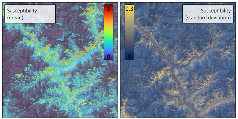
We use multiple geomorphometric and physioclimatic variables as independent features in the susceptibility model. These features comprise, for example, climate indicators reflecting heavy rainfall events, terrain indicators on slope and surface roughness, geology, surface runoff or distance to the nearest road. In total, within the gAia project, more than 50 features, which have been consolidated with experts, are used for modelling [3]. More specifically, we use ensembles of non-parametric machine learning models to predict both an average estimate and a range of possible outcomes, which is used for communicating an uncertainty range of the model predictions. Figure 1 shows a typical visualisation of our landslide susceptibility model based on an ensemble of random forest models.

Figure 1: Landslide susceptibility map (left) and corresponding uncertainty (right). The mean susceptibility is estimated based on an ensemble of random forest models. High values indicate an increased predisposition for landslide occurrence. The uncertainty is the ensemble standard deviation, with higher values indicating higher uncertainty regarding the estimate.
Outlook
Combining expert knowledge with data-driven models for obtaining more reliable landslide susceptibility maps is a powerful way for improving incomplete or contradicting hazard event inventories, as is often the case in climate-relevant applications. In order to make our society more climate resilient, these approaches should be used to strengthen proactive spatial planning and impact-reduction via mitigation and adaptation measures in affected areas.
gAia is funded through the KIRAS Security Research Program for Cooperative Research and Innovation Projects by the Austrian Research Promotion Agency (FFG) and the Federal Ministry of Agriculture, Regions and Tourism, under grant agreement FO999886369.
Links:
[L1] https://www.kiras.at/en/financed-proposals/detail/predicting-landslides-entwicklung-von-gefahrenhinweiskarten-fuer-hangrutschungen-aus-konsolidierten-inventardaten
[L2] https://doi.org/10.1017/9781009157896
[L3] https://www.sba-research.org/research/projects/gaia/
References:
[1] D. Maraun, et al., “A severe landslide event in the Alpine foreland under possible future climate and land-use changes”, Communications Earth & Environment, vol. 3(1), no. 87, 2022. [Online]. Available: https://doi.org/10.1038/s43247-022-00408-7.
[2] M. Schlögl, et al., “On the nexus between landslide susceptibility and transport infrastructure – an agent-based approach”, Natural Hazards and Earth System Sciences, vol. 19(1), pp. 201–219, 2019. https://doi.org/10.5194/nhess-19-201-2019.
[3] J. Lampert, et al., “gAia: predicting landslides based on consolidated inventory data – bridging needs and limitations”, in Konferenzband der Disaster Research Days 2022, pp. 43–45, 2022.
Please contact:
Rudolf Mayer, SBA Research, Austria
Andrea Siposova, SBA Research, Austria


