by Fabrice Saffre (VTT Technical Research Centre of Finland)
Low Earth Orbit (LEO) satellite constellations are fast becoming a reality, but like for many new technologies, making the most out of them may require some innovative thinking beyond the obvious.
There is an ongoing paradigm shift in how orbital assets are being designed and deployed. Whereas it used to be the case that a given mission or specific application (combined with budget constraints) dictated which satellites should be placed onto which orbit, we are increasingly in a situation where potentially “multi-purpose” constellations are being launched with the goal of maximising planetary coverage [1]. Although many constraints and challenges remain, such as the increase in energy consumption and additional onboard equipment required to perform multiple functions, a more versatile space infrastructure would have tremendous advantages. For now, early examples of purpose-built LEO constellations include SpaceX’s Starlink [L1] and the European Commission’s plan for satellite broadband [L2].
In the hypothetical scenario in which software-defined functions make the “satellite-as-as-service” paradigm feasible, existing resources are already circling the Earth at the time when a new, possibly relatively short-term mission (e.g., monitor the course of a suspicious vessel) is being considered. The challenge is then to select and temporarily allocate the best possible subset of available orbital platforms to complete it. Factor in the possibility of multiple concurrent tasks and conflicting priorities and it may become a complex optimisation problem that requires solving in near real-time, which we’re only beginning to comprehend [2].
Extrapolating from previous work [3], we have begun developing a method based on nature-inspired heuristics (including but not limited to genetic algorithms) to identify a target number of satellites among the members of a constellation of arbitrary size/density that would be best suited to collectively perform a particular task. In the selected proof-of-concept, a task is defined as monitoring a given location (latitude and longitude) over a given period (start and end time). In preliminary testing, there are 3 such tasks: 36° N, 20° E (00:00-06:00), 12° S, 12° W (03:00-09:00) and 36° N, 18° W (06:00-12:00).
The arbitrarily set parameters are as follows: the planner has a “budget” of 32 satellites, to be selected in a patchy constellation 256 strong (i.e., one out of eight). The objective is simply to maximise the observation time of all three locations, during their respective (and partially overlapping) time windows. Gaps in coverage (interval between observations) and uneven distribution between tasks are not factored in.
After a heuristic search of approximately ten seconds (HP Elitebook, Intel Core i5 8th Gen), observation time averaged ~7h 45’ (out of a max. possible 18h). For comparison, a random set of satellites (for the same parameter values) averaged ~2h30’ cumulative observation time, i.e., well over 200% improvement (NB: there is a law of diminishing return so a much longer search does not yield substantially better results). Fig. 1 is a snapshot of the simulation identifying the sub-set of satellites that were allocated to the task.
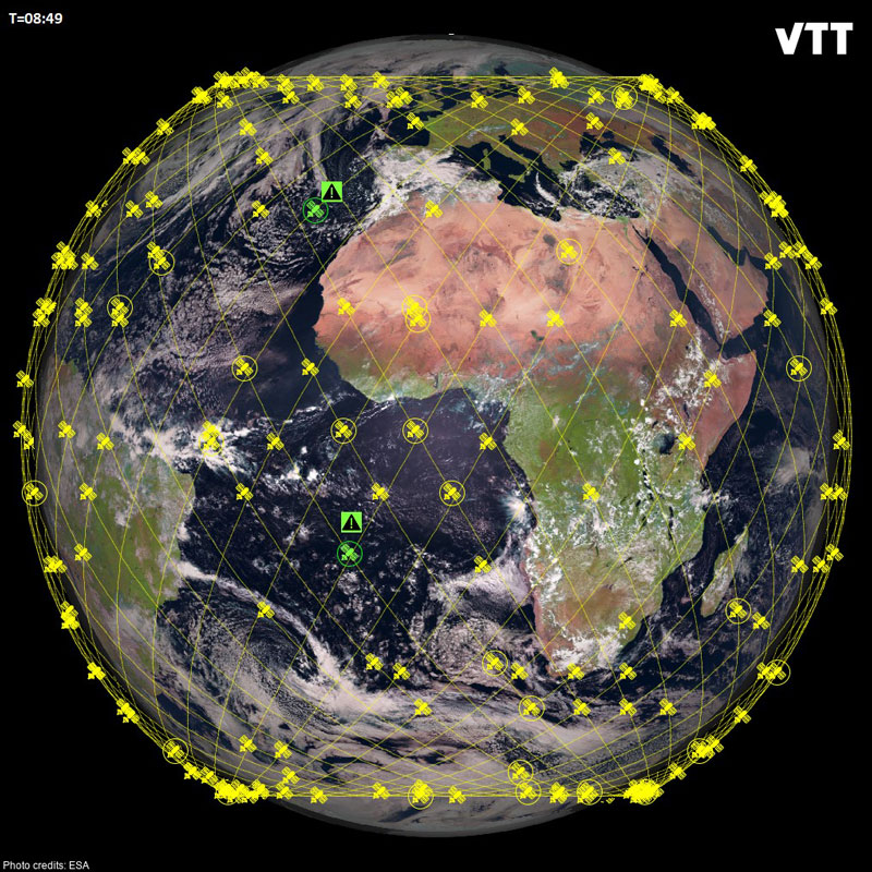
Figure 1: Snapshot of the numerical experiment after heuristic search. Satellites that are circled were selected. A green icon indicates that the satellite was (a) selected, and (b) is above the horizon of one of the designated target locations during the target observation time window (“attention” sign).
A valid discussion point is whether such heuristics will have practical applications. Orbital mechanics are essentially deterministic, which implies that exact calculation methods may be able to identify a better optimum at a lower computational cost. However, the same cannot be said of the tasks (which may be created dynamically and follow an arbitrary and so unpredictable space-time pattern). Furthermore, it can be anticipated that there will be a complexity barrier above which the number of concurrent tasks and/or other factors affecting the “patchiness” of the constellation (e.g., some satellites may be otherwise engaged, undergoing maintenance etc.) will make the flexibility, simplicity and robustness of our method an attractive proposition.
This is very preliminary work, but it perhaps has the merit to illustrate how unconventional methods from a different field can sometimes yield simple, computationally frugal solutions to a complex problem. An exclusive focus on technical feasibility often delivers a new infrastructure that is functional but remains underutilised, due to some operational aspects having been insufficiently researched. Maybe the proposed approach will reveal itself to be impractical, but such “what-if” questions are the conceptual fuel that innovation runs on.
Links:
[L1] https://uk.pcmag.com/networking/132246/what-is-starlink-spacexs-much-hyped-satellite-internet-service-explained
[L2] https://sciencebusiness.net/news/eu-launches-plan-independent-low-earth-orbit-satellite-broadband-communication-system
References:
[1] A. Kak and I. F. Akyildiz, “Designing Large-Scale Constellations for the Internet of Space Things With CubeSats,” in IEEE Internet of Things Journal, vol. 8, no. 3, pp. 1749-1768, 1 Feb.1, 2021. https://doi.org/10.1109/JIOT.2020.3016889
[2] T. Leng, et al., “Collaborative Computing and Resource Allocation for LEO Satellite-Assisted Internet of Things,” in Wireless Communications and Mobile Computing, vol. 2021, Article ID 4212548, 12 pages, 2021. https://doi.org/10.1155/2021/4212548
[3] H. Hildmann, et al., “Termite algorithms to control collaborative swarms of satellites. International Symposium on Artificial Intelligence, Robotics and Automation in Space” (i-SAIRAS 2018), Madrid, Spain, June 4-7, 2018. Published in: European Space Agency Proc. of i-SAIRAS 2018. Retrieved March 8, 2022. https://kwz.me/hqA
Please contact:
Fabrice Saffre, VTT Technical Research Centre of Finland


