


by Andrea Manno-Kovács, András L. Majdik and Tamás Szirányi (MTA SZTAKI)
Over the last three years, the Institute for Computer Science and Control (SZTAKI) of the Hungarian Academy of Sciences (MTA) has been conducting research in the area of smart farming. The Machine Perception Research Laboratory [L1] has been integrating drone-captured aerial images with freely available European Space Agency (ESA) Sentinel satellite imagery to develop an operational system for smart farming applications.
Our first goal is to enhance the limited resolution of satellite images of the test sites by capturing high resolution video footage of the same test areas. To achieve this, we co-register geo-referenced images from different sources and resolutions. Secondly, our goal is to detect changes between images collected periodically with different technologies, and more importantly, to detect and estimate damage in crop production and fruit plantation areas as well as to monitor the natural habitats representing a major role in sustainable agriculture and ecological farming.
In our first project, during the summer of 2017 we periodically collected data with a quadcopter equipped with an RGB and a four channel (Green-550 nm, Red-660 nm, Red edge -735 nm, Near infrared -790 nm) multispectral camera system (i.e., Parrot Sequoia) in three different farming sites in the vicinity of Biatorbágy town, Budapest metropolitan area, Hungary. In the course of the multi-session mapping we captured more than 25,000 narrow-band 1.2 mega pixel images covering 41 hectare (ha) of wheat field, 18 ha of cornfield, and 8 ha of fruit and vineyard. Next, by computing the geo-referenced orthomosaic photo corresponding to every multispectral band we analysed the normalised difference vegetation index (NDVI) at different time instances. Similarly, the NDVI index was estimated using satellite imagery whenever data was provided by the ESA Sentinel satellite in order to track the changes in terms of live green vegetation quantity at the smart farming sites (Figure 1).
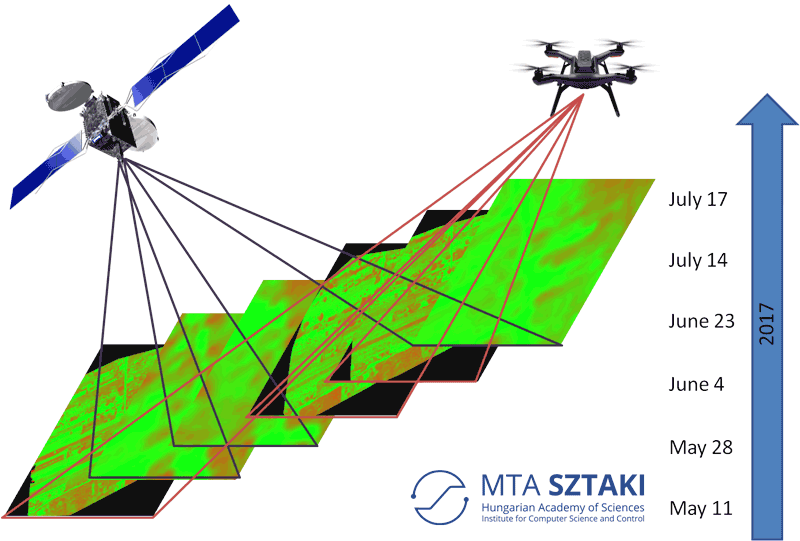
Figure 1: Summary of results: NDVI indexes computed from satellite imagery and low altitude (70 meter above ground) aerial mapping captured at different time instances over the summer of 2017.
Beside, the conservation of natural habitats is also connected to smart farming and sustainable agriculture. Climate change and agriculture are related processes; therefore special emphasis is placed on such methods that preserve and preferably regenerate the ecosystem. EU directives require the preservations of natural habitats (e.g. the Natura2000 habitats) and also the Hungarian government made steps for biodiversity conservation concentrating on three types of habitats: forests, grasslands and wetlands.
While small wetland patches are closely connected to smart farming, this vegetation in the mosaic of the landscape receives far less attention. However, these small wetlands are especially important and should not be modified by agriculture and urbanization, as they provide sanctuaries for wildlife sensitive to human presence. Moreover, they also play an important role in regulating water quality and quantity through pollution absorption, groundwater recharge and flood retention. The small patches of wetland areas give an important contribution to the co-habitation inside agricultural, urban and traffic areas. At the same time, agricultural land acts as a buffer zone around wetlands, protecting them from developing industrial zones and urban areas. Due to this connected relation between agricultural areas and wetlands, smart farming should also concentrate on the tracing and tracking of these small habitats. To monitor such areas, our ESA OWETIS (Observation of local WETland areas from Satellite Imaging) project concentrates on the automatic localization and observation of potential small backcountry wetlands.
In our second project (OWETIS), MTA SZTAKI, together with the Balaton Limnological Institute, Centre for Ecological Research, Hungarian Academy of Sciences (Andras Zlinszky) and Airbus DS GEO Hungary Ltd. (Gyorgy Domokos) performs a nation-wide observation of small local wetland areas from satellite imaging [L3]. As a first step, a GIS dataset has been built, focusing on small, backcountry wetlands which are not connected to large, open water surfaces. The wetland candidates were first selected using Google Maps, then verified in field campaigns with UAVs, the identification is based on the collection of GPS points and polygon data together with field photographs. Beside the location and extent, local water regime, habitat quality (biodiversity) and observation of flora and fauna is also included in the dataset. The database includes the surrounds of the three largest Hungarian lakes: Lake Balaton, Lake Tisza and Lake Neusiedl (Hungarian side). The database contains 150 test patches, out of which 113 are wetlands, providing a good representation of the variety of Hungarian wetlands. Besides wetlands, there are 23 grasslands (also an important habitat type) and 14 croplands.
![Figure 2: Wetland mapping on Lake Balaton - The test patches of the wetland database are shown in yellow, followed by the MRF-based multitemporal segmentation [2] and the test site in Google Maps.](/images/stories/EN113/manno-majdik--sziranyi-2.png)
Figure 2: Wetland mapping on Lake Balaton - The test patches of the wetland database are shown in yellow, followed by the MRF-based multitemporal segmentation [2] and the test site in Google Maps.
The main focus of the project is to use this database to investigate temporal, spectral and spatial characteristics of wetlands using Sentinel multispectral satellite imagery, and from this to develop an automatic detection process, which can provide further information about natural habitats. The detection process applies a fusion based Markov Random Field (MRF) technique [1] on multitemporal and multispectral image series. In our fusion MRF model an unsupervised method tracks temporal changes of wetland areas by comparing the class labelling of different time layers [2]. A classification map based on existing airborne laser scanning data [3] has been used for wetland classification improving the discrimination of land-cover classes with similar spectral characteristics. The proposed method can be extended by machine learning and feature based classification for more accurate monitoring of wetlands.
Links:
[L1] http://mplab.sztaki.hu
[L2] https://kwz.me/hbv
[L3] https://kwz.me/hbw
References:
[1] T. Szirányi and M. Shadaydeh: “Segmentation Of Remote Sensing Images Using Similarity Measure Based Fusion-MRF Model”, IEEE Geosci. Remote Sens. Lett., vol. 11, no. 9, pp. 1544-1548, 2014
[2] M. Shadaydeh, et al.: “Wetland Mapping by Fusion of Airborne Laser Scanning and Multitemporal Multispectral Satellite Imagery”, Int. J. Remote Sens., vol. 38, no. 23, pp. 7422-7440, 2017
[3] A. Zlinszky, et al.: “Categorizing wetland vegetation by airborne laser scanning on Lake Balaton and Kis-Balaton, Hungary”, Remote Sens., vol. 4, no. 6, pp. 1617-1650, 2012
Please contact:
Andrea Manno-Kovacs
MTA SZTAKI, MPLab

