


by Stefano Bilotta, Enrico Collini, Luciano Alessandro Ipsaro Palesi, Paolo Nesi (UNIFI, DINFO, DISIT lab)
Snap4City is a platform enabling decision-makers to efficiently plan and manage city operations. This article is emphasizing CO2 emission reductions through traffic flow optimization.
Improving transportation infrastructure primarily targets the effective reduction of traffic congestion, CO2 emissions, travel time and fuel consumption. These challenges are tackled through optimization strategies that consider the current traffic flow and traffic graphs knowledge. Research in this field focuses on multiple aspects and can be categorised into two main types: a) those enhancing the existing road infrastructure, such as navigation algorithms and public transport planning, and (b) those that propose changes to the existing transportation infrastructure itself, like modifying the road graph structure and traffic signals.
For the existing infrastructure (a) enhancements may impact specific user groups, such as public transport user and drivers using navigation apps, indirectly improving overall mobility. Infrastructure modifications (b), would require city investments and impact all road users. The effectiveness of such strategies is evident in New York City’s 2009 reduction of traffic congestion through the use of taxi GPS data to identify the critical congestion zones.
Simulation tools for assessing the impact of road modifications on traffic distribution are of key relevance for city decision-makers to improve urban mobility and reduce emissions. Many solutions utilise agent-based models which are loaded with virtual or actual data. In those simulators, agents of vehicles navigate in the simulated road network environment according to their described statistical behavior. Examples of simulator tools are SUMO (Simulation of Urban MObility) and PTV Vissim. The simulated traffic flows, and tiny details of the statical behavior of the vehicles, serve as a benchmark for assessing the actual flows. Better results can be obtained by using data coming from real sensors data.
Thanks to the development in the Internet of Things (IoT), it is possible to monitor real-time traffic data such as vehicle flow and density at strategic locations. Traffic Flow Reconstruction (TFR) algorithms leverage this data to compute the traffic in the whole network using neuro-symbolic approaches [1], thus avoiding reliance on virtual simulations alone. This real-time reconstruction offers a precise view of road network conditions in each segment of the road network (also in the road segments in which the sensors are missing), aiding in decision-support systems that monitor and manage city mobility.
The computing of TFR is at the basis of numerous traffic infrastructure calculations and optimization, such as traffic-conditioned routing and crossroad cycling, computation of the match from transportation offer and mobility demand, resulting in what if analysis and optimization (see Figure 1). Recently, these activities, traditionally performed by agent-based simulators, have also become the domain of smarter AI-driven solutions that support decision-makers.
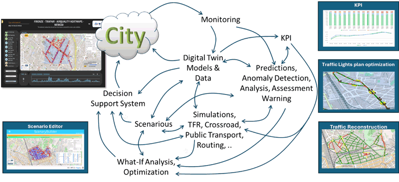
Figure 1: SASUAM Platform architecture for transportation infrastructure optimisation.
The main motivations optimization and what-if analysis targets are the decongestions of traffic and services, improvement of quality of public transportation services, and the quality of life. For example, traffic decongestion can be obtained by reducing the number of vehicles in crowded conditions, which also implies the reducing of emissions, changing/forcing the routing, optimizing the semaphore cycles, etc.; making mobility services more accessible would be obtained by providing more rides or different paths of public transportations and in some cases increasing emissions and expenses. Thus, tradeoff among conflicting targets have to be identified. For this reason, a scenario editor is provided [2], and a large range of interactive visualization tools have to be used for showing the effects and results to work with the decision makers and collect from them final decision and eventually suggestions in short time [3].
A list of artificial intelligence Snap4City tools which can be combined to create solutions for decision makers in improving sustainability of their city is available at [L1]. Snap4City is a platform designed for decision maker to perform activities of operation and plan in the cities and at the support of control rooms. Snap4City is an open-source IoT platform coordinated by the DISIT Lab of the University of Florence. Snap4City is an official FIWARE (an open-source initiative that provides a universal set of APIs to manage Orion broker that allow the development of data flow applications in multiple sectors) and EOSC (European Open Science Cloud) platform and it includes a set of Node-RED libraries for data interoperability and transformation. It is at present in operational use on several federated installations. The Snap4City platform is able to manage multiple tenants and billions of data per day with the key focus on interoperability, decision making, in operation and plan. The Snap4City framework is implemented in several smart cities and areas in Italy (Merano, Cuneo, Florence, Lonato del Garda, etc.) and across Europe (Malta, Rhodes, Varna, Limassol, Valencia, Pont Du Gard, Dubrovnik, Mostar, and West Greece, etc.), by the European Commission on ISPRA JRC, as well as in almost all continents. The largest installation of the platform manages multi-tenant, advanced smart city IoT/IoE applications and involves 20 organizations, 40 cities and thousands of operators and developers.
The project is funded by the CN MOST, PNRR, and by its Scalability subproject SASUAM. SASUAM is a CN MOST scalability project that aims to implement scalable methods and algorithms for urban traffic management.
Links:
[L1] https://www.snap4city.org
[L2] https://www.snap4city.org/997
References:
[1] S. Bilotta, V. Bonsignori, P. Nesi, “High Precision Traffic Flow Reconstruction via Hybrid Method”, IEEE Transactions on Intelligent Transportation Systems, 2023.
[2] L. Adreani, et al., “Smart City Scenario Editor for General What-if Analysis”, Sensors, MDPI, 2024. https://www.mdpi.com/1424-8220/24/7/2225/pdf
[3] P. Bellini, et al., “Snap4City Dashboard Manager: a tool for creating and distributing complex and interactive dashboards with no or low coding”, SoftwareX, Elsevier, 2024. https://www.sciencedirect.com/science/article/pii/S2352711024001006, https://doi.org/10.1016/j.softx.2024.101729
Please contact:
Paolo Nesi, University of Florence, DINFO, DISIT, Snap4City, Italy,

