


by Rasha Abu Qasem (Fraunhofer Institute for Experimental Software Engineering IESE) and Nils Hausbrandt (Rhineland-Palatinate Technical University of Kaiserslautern-Landau)
Decision Support Systems (DSS) have been used for several city planning activities. In this article, we show how DSS can also be used to emphasise inclusiveness in smart city design by assuring the accessibility of services to all citizens, especially vulnerable ones.
Urban and regional planning is a complex procedure. It incorporates multiple regulations alongside many social, environmental and economic factors. This can lead to undesired neglect of some groups of people like people with disabilities or elderly generations, and withdrawal of their needs while planning spaces. Today with the advancement in Information Technology and the shift towards smart cities, this procedure can be made easier by adapting solutions such as DSS. A DSS helps city planners understand the implications of their plans from multiple perspectives and can support them in designing inclusive cities for diverse groups of people.
In our research project “Ageing Smart – Smart structured areas”, funded by the Carl Zeiss Foundation, we investigate the best ways to design and implement a DSS that supports inclusive city design. Our consortium contains a collection of interdisciplinary chairs at the Rhineland-Palatinate Technical University of Kaiserslautern-Landau (RPTU) and two German research institutes: Fraunhofer Institute for Experimental Software Engineering (IESE) and the German Institute for Artificial Intelligence (DFKI).
Inclusive city design is commonly defined in terms of the UNDP Human Development Index [1], which is derived from three factors: economic status, access to and status of education, and access to and status of health. We focus our work on the improvement of inclusiveness in city planning by enhancing accessibility for the city’s services and facilities while considering the spatial mobility of groups that previously did not have access to certain services. As a use case, we study the baby boomer sector in Germany, and we show how to incorporate their current and future mobility needs into the city plans with the help of DSS.
The German baby boomer cohort of the birth years 1955 to 1969 forms 25% of the current population and many of them are in the process of settling into retirement. This will create a high need for many services, especially medical ones. In Germany, there is already a problem in the distribution of General Practitioners (GPs), which are the first point of contact for patients, with an evident lack of them in rural and sub-rural areas. Another problem is that many of the doctors today belong to the baby boomer generation themselves. That will lead to a wave of medical care demands that we need to address in the current city plans.
To better understand the current and foreseen requirements of the different citizen sectors, especially the baby boomers, we have conducted multiple workshops with city officials and planners. The workshops were designed to grasp the status quo of the baby boomers’ behaviours with a particular focus on their mobility requirements. Based on that, we designed the baby boomers' mobility profiles, which provide a quantification of their actions according to the mobility means, i.e. by foot, by car, or via public transportation. The profiles are the input for the analysis model, which is the basic component of the DSS.
The analysis model consists of a reachability analysis model and a location optimisation model. The reachability model offers an intuitive analysis tool that shows the accessibility of services for baby boomers within the city. In our example, we focus on the accessibility of GPs, dental, and general specialist practices as well as hospitals and pharmacies in and from the individual local communities. The reachability modelling enables the decision-makers to assess how resilient the current situation for baby boomers is and to identify the future under-supplied areas. The DSS can thus show the impact of the opening or closing of a GP practice on the accessibility factor or even the impact of relocation or establishment of a new bus route on medical care coverage. The location optimisation model allows the determination of the optimal location for the construction of new neighbourhoods, new clinics, or even new bus stops.
The computations of the analysis model are based on the mathematical theory of intermodal route planning [2] and thus allow reasonable combinations of different means of transport along a route. The user of the DSS can set many parameters such as walking times, public transport transfer times, or the time at which the analyses are carried out. Figure 1 shows a reachability heat map of the GPs in the city of Kusel – a rural German city – at 10.00am, considering the official bus timetable, where travelling is only allowed on foot or by bus, but not by car. The red zones show the places where the baby boomers have problems reaching the needed medical services.
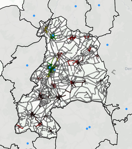
Figure 1: Reachability heat map, which colours each populated area of the city in terms of its distance (on foot and by public transport) to the nearest GP (blue markers). For a distance of less than 15 (15–30, 30–45, 45–60, 60–90, ≥90) minutes to the nearest GP, the areas are coloured green (light green, yellow, pink, red, brown).
We have seen how the basic analysis core of the DSS enables the comparative analysis of different settings and gives the decision-makers a clear understanding of different scenarios at current times and in the future. It also allows them to recognise the impact of their decisions on the baby boomers’ medical care needs and coverage. In other words, the DSS facilitates the inclusiveness of baby boomers in future city plans because of the comprehensive user profile that reflects their behaviours. Building more user profiles for diverse sectors of citizens and highlighting their needs will reinforce the creation of an inclusive smart city that accommodates everyone.
References:
[1] X. Lemaire and D. Kerr, Inclusive Urban Planning – Promoting Equality and Inclusivity in Urban Planning Practices, UCL Energy Institute / SAMSET, London, UK, 2017.
[2] D. Kirchler, L. Liberti, and R. W. Calvo, “Efficient computation of shortest paths in time-dependent multi-modal networks,” ACM Journal of Experimental Algorithmics 19, 2015.
Please contact:
Rasha Abu Qasem, Fraunhofer Institute for Experimental Software Engineering IESE, Germany
Nils Hausbrandt, Rhineland-Palatinate Technical University of Kaiserslautern-Landau, Germany