by Ioannis Kavouras, Emmanuel Sardis and Anastasios Doulamis (National Technical University of Athens, Greece)
Visualise today the city of tomorrow! The rapid evolution of the computer graphics along with the accessibility in high-capacity 3D geospatial information have led to the emergence of new opportunities for engineers and scientists to better understand, visualise and design the urban environment.
The utilisation of Expanded Reality (XR) technologies provides advanced and innovative solutions for many urban planning applications. Moreover, Virtual (VR) and Augmented (AR) Realities can be used accordingly for digitising and visualising (i.e. BIM – Building Information Models, and DT – Digital Twins), and navigating the city environment [1]. Thus, these technologies can be proved useful for multiscale intervention planning, including urban and architectural design.
The combination of the aforementioned technologies with advanced algorithms provided by a game engine framework is capable of generating a serious game for real-time intervention planning, inside a virtual environment, which can be implemented by expert users (e.g. engineers, urban planners, architects, etc.) and non-expert (e.g. citizens, district governors, etc.). Through this platform the civil engineers, urban planners, architects, and other designers can generate a BIM model of their area of interest and build a serious game [2] for implementing several alternative solutions at the same time, over the same area. In a similar way, non-experts can propose their own solutions by playing the game and test them in a safe virtual environment. Thus, for each solution it is possible to visualise in real time the architectural, aesthetic, and environmental impact (i.e. the solution may pass the aesthetic criteria but may not be usable for a city area citizens).
Another advantage of the serious game approach, enhanced with XR frameworks, is its usage for attracting citizens to participate in the urban design process [3], even from the early stages of the intervention process. This is significantly important, because it democratises and decentralises the urban planning process by collecting feedback from interested citizens. The VR and AR characteristics can inspire young people, who are experienced with such technologies, and find it a lot easier than older people, to participate in the planning process and provide feedback. For the non-experienced users (i.e. older people), the interaction with the serious game can be achieved by organizing public workshops or seminars, where they can either play the game with the organisers’ help, or view the game in some screen and instruct accordingly the player (i.e. a workshop organiser) for the placement of the planning feature (co-designing). Human involvement and visualisation of their suggestions and developments in an urban area increases residents and end users socialising behaviour into more democratic ways for urban planning modifications and transformations in modern cities. Public participation promotes inclusivity and diversity in the planning process, incorporating a wide range of perspectives, needs, and preferences.
The euPOLIS Game [L1], which is developed under the EU H2020 project named euPOLIS with GA 869448, is an indicative example of a serious game utilised by AR characteristics. In this game, the player can navigate in the four demo cities of the project (i.e. Piraeus, Lodz, Belgrade, and Gladsaxe) and propose a variety of Nature Based Solutions. To be precise, the player can navigate in the proposed by the euPOLIS project Demo Solution and he can provide feedback in an interactive way by answering in-game questions or filling the respective questionnaire by scanning an in-game QR code. Furthermore, the game provides an empty canvas (i.e. the city as is today) and asks the player to place features, such as trees, benches, etc. For a quick evaluation of the player’s solution, the game provides simplified models for calculating basic metrics, such as temperature, humidity, etc.
Figure 1 illustrates the euPOLIS Game’s proposed Demo solution for the city of Piraeus in Greece. An area under construction and transformation is applied through the proposed game in city residents and stakeholders for proposing related interventions following suggested Nature Based Solutions (NBS) in the specific area. By actively involving community members in the envisioning and transformation of their area, we can harness collective creativity, local knowledge, and a diversity of perspectives. This collaborative process not only ensures that the final urban plans align with the needs of the community, but also fosters a sense of ownership and pride among residents.
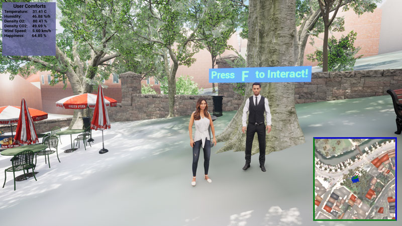
Figure 1: The euPOLIS Game’s proposed Demo solution for the city of Piraeus.
For the development of the final proposed solution (Figure 1) more than 30 participants were involved actively providing their opinions and ideas. The participants were from various age groups from younger (i.e., teenagers) to older (i.e., over 60 years old) people. Each participant designed an intervention solution by added features (i.e., foliage, benches, etc.) from a predetermined pool supporting object related to the needs of the euPOLIS project in a dedicated pilot city area (pocket park in Akti Dilaveri in Piraeus, Greece). For the older people who couldn’t use the application, an expert assistant helped them by following and respecting their guidelines. Finally, the proposed solutions were evaluated by a group of experts and the final design resulted by considering the combination of both the environmental impact of green solutions and the activities (i.e., a playground for kids and tables/benches for the parents to sit) that proposed by the majority of the participants.
In summary, today programming technologies provide new solutions for 3D game development, from a real area for navigating and visualising different scenarios of interventions, based on XR technologies, without affecting the actual environment. The proposed game can be used for visualising several alternative solutions that can help the architects, designers, urban planners, and engineers to decide on alternative solutions for an area. In addition, these technologies can be shared with the interested public for democratising and decentralising the intervention planning process. This approach can lead to positive modifications and transformations in modern cities that truly reflect the needs and desires of the people who live in them. Thus, this technology can effectively visualise today the city of tomorrow!
This work is supported by the European Union Funded project euPOLIS ”Integrated NBS-based Urban Planning Methodology for Enhancing the Health and Well-being of Citizens: the euPOLIS Approach”, under the Horizon 2020 program H2020-EU.3.5.2., grant agreement No. 869448.
Links:
[L1] https://eupolis-project.eu/2023/06/21/urban-planning-gamification-by-eupolis/
References:
[1] I. Kavouras, et al., “Dynamically tangible cultural heritage monitoring from web video sources,” in Proc. of PETRA '23, 610–616. https://doi.org/10.1145/3594806.3596552
[2] I. Kavouras, et al., “Effectiveness of Open-Source Solutions for Limited Scale Interventions Planning,” Novel & Intelligent Digital Systems Conferences, 2022.
[3] I. Kavouras, et al., “A Low-Cost Gamified Urban Planning Methodology Enhanced with Co-Creation and Participatory Approaches,” Sustainability, 15.3 (2023): 2297.
Please contact:
Ioannis Kavouras, National Technical University of Athens, Greece

