by Adrian Grenham
The ultimate vision for the Sensor Web is to use service-oriented architecture (SOA) techniques and the ubiquitous power and utility of the Web to integrate billions of static and mobile sensors that are already present in the environment. The resulting capability will release an unprecedented wealth of environmental monitoring information at all levels: global, national, regional and local. In order to investigate and demonstrate one aspect of this vision, SciSys research is working on the automatic triggering of satellite-based observations by in situ alerts.
The value of earth observation satellite imagery in monitoring changes in the environment is largely dependent on the timeliness of the data acquisition. Models routinely used to forecast weather and related natural phenomena such as floods, employ sophisticated numerical analysis techniques to provide forecasts from hours to many days in advance. Many of these models rely on information from large numbers of (often heterogeneous) in situ sensors; these collect diverse data including soil moisture, river levels and peak flow, coastal tide conditions and rainfall. Access to in situ sensors tends to be ad hoc, employing widely different protocols and data formats.

The goal of the Sensor Web is to provide a network that links ground and space-based instruments for autonomous and collaborative observation services. Ideally this is achieved by the seamless integration of software and communications links between sensors. Typically models raise alerts concerning events of interest; an observation campaign is then triggered that employs an ad hoc and dynamic set of sensors. Subsequently, data is acquired as quickly and in as much depth as possible in a given time period. In this example a satellite instrument can be tasked to provide imagery for constructing before and after sequences to aid situation awareness, defence planning and relief activities if needed.
The aim of the Open Geospatial Consortium (OGC) Sensor Web Enablement (SWE) specifications is to create Web-based sensor networks that will make all sensors and sensor data repositories discoverable, accessible and (where applicable) controllable via the worldwide Web. It is a revolutionary approach to exploiting Web-connected sensors, and represents an extension of the concepts widely demonstrated by the Web Map Service (WMS), Web Feature Service (WFS) and Web Coverage (WCS) specifications that facilitate interoperability in geospatial Web services.
Besides the principles governing Web services, the OGC specifications describe the functionality of the Sensor Web:
-
discovery of sensor systems, observations, and observation processes that meet the immediate needs of an application or user
-
determination of a sensor's capabilities and quality of measurements
-
access to sensor parameters that automatically allow software to process and geo-locate observations
-
retrieval of real-time or time-series observations and coverage in standard encodings
-
tasking of sensors to acquire observations of interest
-
subscription to and publishing of alerts to be issued by sensors or sensor services based upon certain criteria.
The specifications allow Web-resident sensors to be discoverable and accessed through a set of self-describing software services. A dedicated profile of XML, SensorML provides a generic description of any sensor type that can be queried for any accessible sensor. The profile includes modelling sensor response as a process that may be described as a data transform specific to a physical device (eg an actuator, detector or filter). Individual processes can be combined into more complex processing chains that satisfy some real-world problem.

SciSys is involved in a European Space Agency project to test intelligent satellite tasking. The satellites are triggered by alerts raised by a Sensor Web based on a prototype implementation of the OGC specifications. The project comprises an international consortium including GIM (Belgium), VITO (Netherlands), SpaceBel (Belgium), Soldata (Spain) and GeoID.
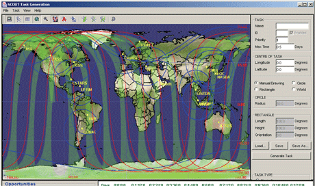
The project will deliver a flood-monitoring service integrated into the ESA-ESRIN Service Support Environment (SSE). Users will be able to subscribe to receive flood alerts issued for a defined geographical area of interest. The service will provide users with a set of satellite-imaging opportunities by querying an SWE Sensor Planning Service (SPS) that acts as the asset controller for a number of satellite SAR missions. The orbit description, sensor and tasking details for each mission are used to determine the earliest opportunity to image the target area. The SPS "submit" operation formats a tasking request including all the parameters required by the relevant mission-planning system.
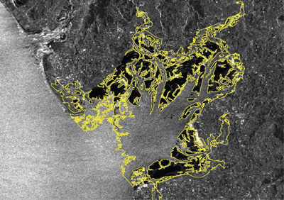
The prototype testbed will be used to simulate the provision of timely SAR images of Morcambe Bay in northwest England. These can show the orientation of highly mobile river channels prior to forecasted flood events, adverse weather and seasonal high tides. Mapping the channels in advance of exceptional tide conditions makes it possible to assess the location and effectiveness of sea defences and to alert populations likely to be affected.
Currently such satellite tasking remains a largely manual process and requires fairly long lead times. However, with warnings issued 6 to 48 hours prior to an event there is an obvious potential to acquire timely data through improved responsiveness to flood alerts.
Links:
SciSys: http://www.scisys.co.uk/
OGC: http://www.opengeospatial.org/
Please contact:
Chris Lee
Head of Sales and Marketing (Space Systems), SciSys Ltd, UK
E-mail: chris.lee![]() scisys.co.uk
scisys.co.uk


