


by Umberto Maniscalco and Giovanni Pilato
Soft sensors are innovative tools for the acquisition of measurements in complex experimental conditions. We present a set of soft sensors designed for the spatial measurement forecasting of environmental atmospheric parameters in order to solve the problem of non-invasive monitoring of archaeological sites.
For the conservation of cultural heritage it is crucial to have non-invasive tools capable of monitoring both the physical and chemical conditions of the various materials composing the artefacts. The classical approach to artefact monitoring is to apply physical sensors to the artefact for a long time. These sampling campaigns must be repeated many times. This is a long process and such actions are typically hard to realize because they are expensive and/or invasive, reducing as a consequence the attractiveness and the full-fruition of the site. For this reason, in the context of the SIINDA project (an Italian national project regarding the study and the development of an integrated approach for computer aided cultural heritage conservation), we were asked by the “Agency for Cultural Heritage of the Aosta Region, Italy” to find a solution for the non-invasive monitoring of cultural heritage sites.
We propose to employ the soft sensor paradigm. Soft Sensors, known also as virtual sensors, are software tools capable of calculating quantities that cannot be measured or that are difficult to measure. They are based on technologies that provide an estimation of measurements by creating a mathematical model from real data. This approach allows the computation of a given variable value from other measurements that are related to it.
Our methodology realizes a spatial forecast of environmental parameters in the presence of one or more atmospheric monitoring stations (AMS) in the neighbourhood of the artefact.
The spatial forecast is based on a number of neural networks organized as an interconnected system. In this system, each neural network (or group of neural networks) constitutes a single soft sensor capable of capturing the associative model among the data and to estimate accurately an environmental parameter value in a specific spot of the artefact. As the associative model is induced through a data driven approach, a set of sensors must be installed on the artefact for a reasonable (preferably short) training time in order to measure these parameters. After the training phase the set of sensors is removed from the artefact.
Once the soft sensors have learned the associative model, we can derive the parameter values that would have been measured by physical sensors. This is achieved using the AMS as the data source and the set of soft sensors as the forecaster. This approach is conceived as a general methodology that can be employed for the non-invasive measurement of critical parameters in cultural heritage sites.
Damage to artefacts are always the result of interaction between the materials composing the objects and the environmental factors, including pollutants, surrounding them. In particular, the physical and chemical properties of the materials composing the artefact typically change in an attempt to reach equilibrium with the environment. The state of the artefact is thus dynamic, and will change according to atmospheric parameters. This means that the recognition of a critical state in the environment, and the knowledge of the time period during which this state will remain critical, is extremely important, since it is the pre-condition of a degradation process. Therefore, we have adopted and adapted the soft sensor technology to develop a new methodology for the non-invasive measurement of atmospheric parameters.
We have designed and developed several kinds of soft sensor based on different models of neural networks and have analyzed how well they are able to estimate the measurements from a metrological point of view. The idea is to make them work as a substitute for physical sensors. We have introduced and adopted an “ad hoc” validation procedure, which consists of two phases: a statistical phase based on several statistical estimators, and a validation by comparison phase. This procedure is based on a “substitution error” that we have defined as the difference between the values estimated by a soft sensor and the measurement provided by a real sensor.
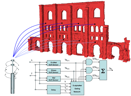
Figure 1: Overview of the spatial forecast and HyperSensor architecture.
Recently, we introduced the HyperSensor architecture (see Figure 1): a mixture of several soft sensors, based on different neural network models. The performance of this new architecture has been statistically analyzed. In comparison with traditional soft sensor architectures, this architecture gives better results for each evaluator and in any measurement condition.
Our methodology has been applied to the Roman theatre (see Figure 1) in the city of Aosta for which we have a suitable set of atmospheric parameters measured both by two AMSs located close to the theatre and by real sensors placed on the theatre.
The effectiveness of the methodology in monitoring cultural heritage sites has been validated and approved by the Cultural heritage authorities of Aosta.
Please contact:
Umberto Maniscalco or Giovanni Pilato
ICAR-CNR, Palermo, Italy
E-mail: {maniscalco,pilato}@pa.icar.cnr.it
{jcomments on}
