Auto AR – In Situ Visualization for Building Information Modelling
by Leif Oppermann
Being able to explore vast outdoor scenery, cityscapes, or the interior of virtual buildings is the state of the art for video gamers. But city planners and building owners usually still have to settle with blueprints, rendered movies, and miniature models. Fraunhofer FIT’s innovative “Auto AR” system allows the user to experience virtual building models on site, almost as if they were already built.
Workflows in architecture, engineering and construction are currently undergoing the second major renewal in the past 20 years. After the significant move from ink-based drawings to Computer Aided Design (CAD) came the move to full 3D building models. Those models are now continuously linked with additional meta-data and regarded as the central digital model of the whole building process. The resulting digital collaboration process is also known as Building Information Modelling (BIM). It is considered to be a game changer to successful building in the future, and is described in government strategy plans of several countries, including the UK [1] and Germany [2]. The underlying assumption is that digitally facilitated collaboration will enable better teamwork and thus greater efficiency and better outcomes for all stakeholders.
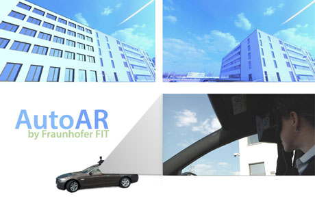
Figure 1: Auto AR system allows the user to experience virtual building models on site. Photo: Fraunhofer FIT, VWFS, Oltmanns und Partner, DhochN, Büro Gaudlitz.
Auto AR uses these digital building models and allows visualization of them live on site via a head-mounted display, and also records data for later use in the office. We employ a 360° panoramic camera that is attached to the roof-top of a car and connected to a laptop workstation in the car. Together with the high quality position and orientation sensors this provides the basis for a real-time and centimetre precision visual overlay of building plans onto the camera capture of the real environment. This car-based setup can easily be driven to any construction site or development area to quickly capture views of the planned construction project.
The co-driver of the car wears a head-mounted display which shows the live-view of the panoramic camera according to the user’s head movement, thus effectively showing the existing built-up environment of the neighbourhood. But once the car gets near to the construction ground, the display allows for a virtual time warp. Instead of just seeing the empty site, the co-driver now sees erect virtual buildings in perfect 3D perspective superimposed on top of the background video. The 3D-models are placed exactly where planned and show all the details that the architect put into them. Even variations are possible, maybe showing different entrances or facades that could not be agreed on without seeing them in the context of the surrounding area. This allows for more targeted discussions and better decisions on site, and also remotely later while replaying the recorded data.
The system uses proven technology from the engineering and game domains and combines them into one compelling solution. Examples for this are the industry-grade panoramic camera and survey equipment, as well as the virtual reality head-mounted display and the commercial-grade 3D engine. The camera image is combined with a high frequency, real-time kinematic system to provide for a high precision GPS-coordinate. The viewing direction of the user is continuously measured via the head-mounted display and merged with the position and orientation of the car.
The live-experience of architectural planning could for example be applied to the presentation of alternative designs to committees and decision makers, or be integrated into public participation processes to support the much demanded improved communication of plans. And if building plans have to be changed again, the previously recorded panoramic video footage can be easily recycled, because the visualization is separated from the background video. Video and 3D visualization are only ever merged live during real-time playback, which saves recording and rendering costs. Moreover, viewpoints of special interest can be quickly accessed like chapters on a DVD, so users such as developers and real estate agents could easily use it for their sales communication.
In addition to the exterior view of the building from the panoramic camera perspective, it is also possible to leave the pre-defined track and walk into the buildings. Thus, stakeholders including architects, BIM managers, building owners, investors, and future tenants benefit from a much improved spatial understanding of the three-dimensional plans and can also quickly try out different designs and variations for the interior plans.
The use of AR for BIM has been suggested previously [3], but no one has really applied it to the process so far. Auto AR system is the result of a Fraunhofer internal strategic investment project. Such projects are awarded to innovative ideas whose results could then be further explored in future research and development projects. We are at this stage now and thus currently looking for new opportunities to apply this unique AR-technology to future automotive and building information modelling projects.
Link:
http://www.fit.fraunhofer.de/mars
References:
[1] Government Construction Strategy - Publications - GOV.UK, [online], https://www.gov.uk/government/publications/government-construction-strategy, consulted Aug. 2015.
[2] BMVI - Pressemitteilungen-Abschlussbericht der Reformkommission Großprojekte, [online], http://www.bmvi.de/SharedDocs/DE/Pressemitteilungen/2015/060-dobrindt-reformkommission.html, consulted Aug 2015.
[3] X. Wang, P. E. Love: “BIM + AR: Onsite information sharing and communication via advanced visualization”, in 2012 IEEE 16th International Conference on Computer Supported Cooperative Work in Design (CSCWD), p. 850–855, 2012.
Please contact:
Leif Oppermann
Fraunhofer FIT, Germany
Tel: +49 2241 14 27 24
E-mail:


