by Massimo Martinelli, Davide Moroni and Ovidio Salvetti
We believe that the contribution of volunteers could play a fundamental role in monitoring and protecting the environment. People at sea sighting pollution caused by oil or hydrocarbon spillages can now immediately report this using a freely downloadable mobile application.
{jcomments on}At the Signals and Images Laboratory (SI-LAB) of the Institute of Information Science and Technology of the National Research Council of Pisa (ISTI-CNR), we have developed a Marine Information System (MIS) for monitoring vessel traffic and oil spills within the Mediterranean basin. The MIS collects and integrates geotagged data related to safety and health issues of the sea from various sources (satellites, optical sensors, electronic noses, autonomous underwater vehicle systems) and provides predictive models to assist the authorities in the management of emergencies at sea.
An integrant part of the MIS is represented by the data that can be collected and shared by volunteers who want to collaborate in monitoring the status of the sea.
For this purpose, we have developed ARGO Sentinel, a free application for smartphones with a Geolocation System (GPS)[1]. Two versions of the app have been implemented: an HTML5 version, running as an Opera widget distributed only to our partners of the ArgoMarine project, and a native Android (v2.2 or higher) publicly distributed because of its level of stability, and downloadable by anyone from Google Play (see Link below).
The app was conceived on the intuition that the contribution of volunteers could play a fundamental role in monitoring and protecting the environment. Using the app, whenever someone at sea sights signs of oil or hydrocarbon pollution they can immediately report this to the SI-LAB in Pisa. The information is recorded in the MIS and complements the data obtained from more traditional sources (eg satellites), improving the quality and coverage of marine monitoring, especially in protected areas. In this way we can build up a detailed map of the status of our seas.
The application – distributed in Italian, English and Greek –sends reports of suspected spills to our Lab, providing a description of the spill and specifying the precise point and severity.
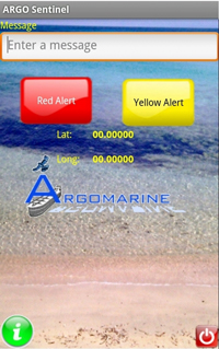
The main screen of ARGO Sentinel shows: a "Message" area where a description of the sighting is entered; a "Red Alert" button to signal a major oil-spill with a diameter greater than or equal to 20 meters approx.; a "Yellow Alert" button: to report a mild/moderate amount of oil spill with a diameter less than 20 meters approx.; an "i" button: for information on the use of the app; an "exit" button to close the app (See Figure 1).

By clicking on the red or yellow alarm buttons, an SMS is sent to the CNR headquarters, which will process the received data.
The app has been installed by about 700 individuals all over the world. By integrating the alerts sent by the volunteers with all the other information sources collected in the MIS, a semi-automatic analysis eliminated the alerts identified as false positive. Even though we have no formal obligations as the project is for research purposes only, we forward all the significant information to the General Command of the Italian Coast Guards in Rome, Italy.
Our field tests demonstrate that the use of this new technology could be really important in combating pollution. Our experience suggests that this kind of technology can be applied to many other fields where environmental monitoring and safety is crucial.
An important result is that, during the period of the project’s activity, we have acquired a more detailed and immediate knowledge of the conditions of the sea. The use of this application represents a step forward in marine environmental monitoring, because, in addition to the other technologies that are used by the Argomarine project, it also adds the contribution of volunteers who can easily communicate the sighting of a spill. Knowing that deliberate spills can be detected in a timely fashion is in itself a deterrent to malicious actions. Possible developments may allow a more effective intervention by the authorities.
A new version of the ARGO Sentinel app is now under development and will also be released for iOS user.
ARGO Sentinel is has been developed in the framework of the European research project ArgoMarine, ("Automatic Oil spill Recognition and Geopositioning integrated in a Marine Monitoring Network") which aims at traffic and marine pollution monitoring. Coordinated by the Tuscan Archipelago National Park, the partners of ArgoMarine include ISTI-CNR, the National Technical University of Athens, the Nansen Environmental and Remote Sensing Center, the Centro de Investigação Marinha and Ambiental, Universidade do Algarve, the National Maritime Park of Zakinthos, the Joint Research Center and the NATO Undersea Research Center.
Links:
ARGO Sentinel: http://tinyurl.com/argosentinel
Argomarine Project: http://www.argomarine.eu
Reference:
[1] “ARGO Sentinel: the application for reporting oil spillages at sea”, http://www.cnr.it/istituti/FocusByN_eng.html?cds=074&nfocus=22, CNR Focus, National Research Council, 2012
Please contact:
Massimo Martinelli
ISTI-CNR, Italy
Tel: +39 050 621 28 03
E-mail:


