by Carola Salis and Eva Lorrai
Among its several branches, the Centre for Advanced Studies, Research and Development in Sardinia has a department which focuses on the research and development of remote tools for e-learning. The aim of the Web Geographic Information System (Web-GIS) for Culture (WGC) project is to create a database of Sardinian museums that will provide school teachers with useful and detailed information about the nature of the exhibit characteristics and the related activities, thereby helping students to derive the greatest benefit from their museum visits. The WGC is a methodological and technological framework that, once established, will enable access to and updates of museum activities.
In selecting suitable cultural events for their pupils and preparing them to assimilate new knowledge, teachers face considerable difficulties. Despite the obviously practical nature of a museum visit, in the case of many students it still fails stimulate any significant construction of cultural knowledge. Virtual museum environments are becoming more common, and according to Dillon this phenomenon increases the involvement of visitors by better preparing them for the real visit. Good examples are given by the museum of Alaska in its geo-historical aspects or the Cité des Sciences et des Technologies (a scientific and technological museum) of la Villette in France. In these examples, didactic activities to be completed before and after the visit have been created, thereby guaranteeing a complete cycle of learning. Along similar lines, the WGC system should offer an innovative opportunity within the Sardinian education system.
Technology and Features of the WGC System
The database will be presented in a Web-GIS form. In this way, the system will be introduced in a territorial context, and integrated with many other information layers. The Open GIS Consortium (OGC) Geography Markup Language Implementation Specification describes an encoding specification for geodata in XML that enables the storage, transport, processing and transformation of geographic information. The specification defines interfaces for data access and manipulation operations on geographic features, using HTTP as the distributed computing platform. Via these interfaces, a Web user or service can combine, use and manage geodata (the feature information behind a map image) from different sources. For the development of WGC the University of Minnesota MapServer has been chosen as the development environment for building spatially enabled internet applications.
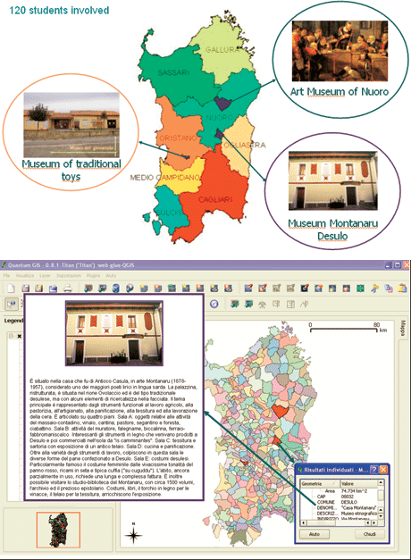
The following components have been selected for the GEM application:
- Apache HTTP server
- PHP
- MapServer CGI (Common Gateway Interface)
- PHP/MapScript
- GDAL (Geospatial Data Abstraction Library)/OGR utilities: GDAL is a translator library for raster geospatial data formats that is released under an open source licence. As a library, it presents a single abstract data model to the calling application for all supported formats. The related OGR library (which lives within the GDAL source tree) provides a similar capability for simple features vector data. UMN MapServer can use GDAL to access TIFF/GeoTIFF, EPPL7 and many other formats, and OGR to access ESRI Shapefiles, PostGIS, ESRI ArcSDE, Oracle Spatial, MySQL and many others.
- MapServer utilities
- OGR/PHP extension
- OWTChart: the OWTChart Engine produces GIF images of virtually any type of chart from a set of input parameters. The program can be used as a CGI in a Web server environment.
Crossing access queries is a peculiarity of GIS database organization, which is a powerful tool for retrieving data and a very helpful approach to making decisions, especially when teachers must deal with large quantities of data. The WGC system will present the following access entries:
- geographical area
- theme
- authors
- pedagogical objectives/activities
- virtual pathway through the museum
- museum classification.
Piloting the Experimentation
The WGC development started last April and we plan to initiate experimentation before the end of this year. At least 120 students will be involved in the WGC experiments. They will start with the preparation phase of the visit to a museum chosen by their teacher. They will continue with the real visit to the museum, followed by the online didactic activities with participation in a virtual game through the WGC system and, finally, will take part in the whole evaluation phase (learning evaluation, level of appreciation, level of participation). Half of the 120 subjects will constitute the control group (CG). Twenty primary school children will visit the Museum of Traditional Toys situated in Ales, while a further twenty will represent the control group. Twenty lower high-school pupils will visit the Art Museum of Nuoro (MAN) and the same number of subjects will constitute the CG. Twenty students of the classical lyceum will visit the house museum Montanaru of Desulo and again, the same number of subjects will constitute the related CG. We plan to produce the last report on the WGC application in June 2008.
Links:
http://www.crs4.it
http://opensource.crs4.it/ict/doku.php
Please contact:
Carola Salis
CRS4, Italy
Tel: +390709250315
E-mail: calis![]() crs4.it
crs4.it
Eva Lorrai
Tel: +390709250227
E-mail: eva![]() crs4.it
crs4.it

