by Matthieu Molinier
Traffic monitoring is becoming increasingly important in the planning of transportation and infrastructure in urban areas. Video sensors can capture detailed information about the nature and speed of moving traffic objects. VTT has developed a generic tool for traffic monitoring, which allows the interactive definition of traffic events and stores position and speed records in geocoded (GIS) form for later analysis. This tool is being used by the Helsinki City Planning Department for intersection monitoring and for the joint analysis of vehicle and pedestrian behaviour near pedestrian crossings.
As traffic volumes increase in urban areas, so does the need for and interest in traffic monitoring for purposes such as city transportation planning or safety analyses. With the improvement of image-processing techniques, video sensors are becoming one of the natural successors to loop-detectors for traffic studies. Video allows traffic objects like buses, cars, pedestrians and bicyclists to be identified, and their speeds estimated. On a higher level, video analysis can help in describing the interactions between traffic objects and in detecting events or incidents such as failure to give way. Yet it remains difficult to provide reliable tracking in congested conditions that generate highly occluded scenes. VTT is developing a generic tool for traffic monitoring that can extract relevant traffic parameters from videos and store the results in GIS (Geographic Information System).
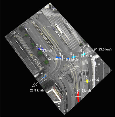
Method development started on image sequences acquired from helicopters, as these can cover a greater area than ground-based systems. The methods were then applied to static ground-based cameras, on which the majority of traffic-monitoring systems are based. The processing chain includes image geocoding and moving-pixel detection followed by tracking of moving objects. The first image of the sequence was manually registered to a GIS map to allow vehicle speeds to be later evaluated in meaningful units. The pixels in motion were then detected by adaptive background subtraction, which iteratively constructs an image of the background (static pixels), and subtracts it from the current image in the video. Moving objects were aggregated and tracked throughout the sequence by spatiotemporal connected-component analysis. This simple approach allowed most of the noisy pixels to be discarded while spatiotemporally consistent targets were tracked. In case of helicopter-based sequences, semi-automatic image-sequence stabilisation was carried out as pre-processing. The methods were successfully tested in an aerial image sequence acquired at an altitude of 200 metres (Figure 1), as well as with ground-based cameras.
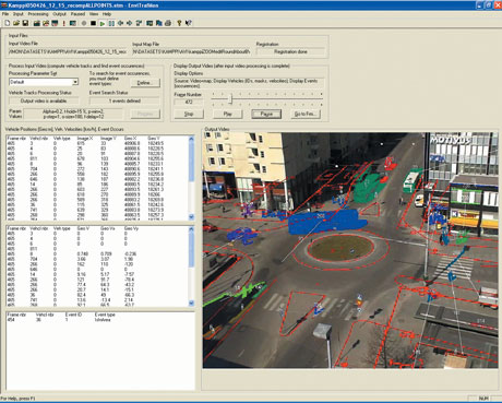
The methods have been integrated with a piece of software known as TRAFMON, which has a Graphical User Interface (GUI) and allows semi-automated and interactive analysis of image sequences for traffic monitoring. The user can draw a zone of interest in the scene and associate events with it, eg a vehicle stopping or slowing down in this zone. The 'philosophy' of the tool is to aid later analysis by extracting from every frame of the video all the relevant traffic information (eg vehicle positions and speeds in real-world coordinates, and triggered events). Records are then stored in tabulated text files, and can be used in replay mode for displaying information (Figure 2). They could easily be used for computing traffic density, vehicle speed profiles or other parameters useful to traffic engineers. The huge amount of data generated by several minutes of video can be used in data mining; for example, identifying typical vehicle behaviour at a given intersection. The tool has proved useful at Helsinki City Planning department, assisting intersection-monitoring tasks that were previously done manually.
This work was part of a larger project, ENVIMON (Environment Monitoring using Earth Observation), the purpose of which was to develop a general software platform utilizing Earth Observation data. ENVIMON benefits the TRAFMON software by providing a set of tools for image pre-processing and post-processing; where necessary, these can also enable the distribution of data and processing results via the Internet. Further work in the traffic-monitoring project will be supported by the Finnish Ministry of Trade and Industry and the Helsinki City Planning Department, and will include making improvements to the tracking procedure for ground-based imagery and to the handling of occlusions of vehicles by other vehicles. The ability of TRAFMON to define events involving more than one object, eg two vehicles approaching each other in a collision course, will be enhanced. We are looking forward to developing collaborations with traffic consulting companies, and possibly with other European research institutes within the FP7 program - partners are welcome!
Link:
ENVIMON Traffic monitoring website: http://virtual.vtt.fi/virtual/proj2/envimon/traffic.htm
Please contact:
Matthieu Molinier
VTT, Finland
Tel: +358 20 722 7345
E-mail: matthieu.molinier![]() vtt.fi
vtt.fi
