by Cyril Ray, Thomas Devogele, Valérie Noyon, Mathieu Petit, Sebastien Fournier
and Christophe Claramunt
At the Naval Academy Research Institute in France, collaborative research in the fields of Geographical Information Systems (GIS) and maritime transportation is producing data models and computing architectures that favour the development of traffic monitoring and analysis for decision-aid systems.
Safety and security are constant concerns in maritime navigation, not least because of the constant increase in maritime traffic and reduction of crews on decks. This has favoured the development of automated monitoring systems such as the Automatic Identification System (AIS) and the Electronic Chart Display and Information System (ECDIS). However, officers on the watch and monitoring authorities require additional and advanced decision-aid solutions that will take advantage of these communication and cartographical systems.
The development of geolocalisation, information and telecommunication technology offers higher traffic data availability, but presents new challenges for the integration, analysis and delivery of maritime traffic data. Hence there is a great need for integrated traffic systems that are able to cope with all these technological domains. The development of a real-time integrated maritime platform implies a reconsideration of storage, modelling, manipulation, analysis and visualisation functions, since current models have not been designed to handle such dynamic phenomena.
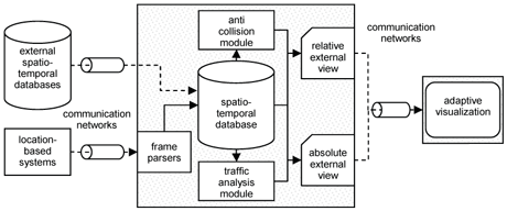
One of the most promising solutions to this problem is the integration of Geographical Information Systems (GIS) with maritime navigation systems. Our approach relies on a monitoring project, the purpose of which is to integrate heterogeneous positional data from three sources: an Automatic Identification System (AIS), public traffic data available from the Internet, and a real-time monitoring system developed for sailing races. These systems generate geolocalisation frames from different types (eg AIS frames) and from different ad-hoc networks (eg VHF for AIS, WiMAX for sailing races). Coupled with external databases, this constitutes the input for an internal spatio-temporal database that manages historic and real-time data. These data include maritime trajectories, vessel characteristics and environmental data.

The framework developed so far integrates several modules. One of these is an anti-collision function that monitors the risk of running aground and evasive ship behaviour. This module also integrates simulation capabilities in order to control and predict the evolution of ship behaviour and trajectories. These simulations are based on a multi-agent system and micro-simulation capabilities, where ships are modelled as autonomous agents acting in their environment according to maritime rules. The module is designed for maritime authorities and for educational and training purposes. Moreover, the traffic analysis module integrates intelligent inference mechanisms that can use data mining to derive traffic patterns. The objective is to observe and understand maritime traffic at different levels of granularity.
Two complementary external views are of interest in maritime traffic monitoring. One is the conventional absolute view of spatial trajectories. The other combines the relative position and velocity of mobile ships with respect to an observer. This relative external view helps users to perceive traffic evolution according to their point of view and aids their perception of the underlying processes that emerge from the ships’ behaviour.

Current research into users’ interaction with the system is focusing on the concept of adaptive GIS. This can be defined as a generic and context-aware GIS that automatically adapts according to its context. The context is defined by (i) the properties and location of the geographical data being manipulated (eg maritime traffic data); (ii) the underlying categories that reflect different user profiles (eg port authorities); and (iii) the characteristics of the computing system, including Web and wireless techniques. In all, the use of adaptive GIS as a decision-aid system appears to be a useful approach for maritime transportation systems.
The framework developed so far represents a preliminary step towards the development of integrated GIS and maritime information systems. A number of research challenges remain. One is the development of cross-domain protocols and exchange standards for the transmission and interoperability of traffic data; another is the integration of different geographical information sources that are combined, adapted and shared in real time between different levels of users acting in the maritime environment. Conventional statistical, geographical data analysis and visualisation methods should also be adapted to the specific nature of maritime traffic information. Traffic data and applications are usually physically allocated in different geographical locations and are computationally expensive in terms of the data volumes generated. Hence, there is also a need at the implementation level for the development of a GIS-based distributed computing environment, and computational and processing capabilities. Overall, the development of GIS for maritime information systems should improve the management and planning of maritime navigation, thus favouring the search for a safer sea.
Links:
GIS research group of Naval academy:
http://www.ecole-navale.fr/fr/irenav/groupes/sig/sig-en/
Please contact:
Cyril Ray
Naval Academy Research Institute, France
Tel: +33 298233611
E-mail: ray![]() ecole-navale.fr
ecole-navale.fr


