by Christophe Joubert, Miguel Montesinos and Jorge Sanz
Galileo, the global navigation satellite system funded by the EU, will soon provide highly accurate and precise position measurements on Europe's roads. But the primary mode of international trade, the maritime industry - responsible for nearly 90 percent of world trade - still relies on outdated technology with limited precision capacity whilst being relatively expensive and inefficient, namely: Electronic Chart Display Information Systems (ECDIS) or paper charts in conjunction with GPS receiver and laser-based Berthing Aid Systems (BAS). Improvements in port traffic management and operational efficiency, as well as reductions in operating expenses, CO2 emissions and the environmental impact of shipping can all be achieved by providing the necessary centimetre positioning/speed accuracy based on WiMAX and PDGNSS technologies. We have developed a set of built in devices and solutions on top of existing maritime embedded devices to form a safer integrated cyber-physical system for maritime transport.
The aim of the European project DOCKINGASSIST (FP7 - 286828, November 2011-October 2013) was to develop a novel wireless network based on IEEE 802.16-2009 [1], WiMAX, in order to create a centralized, cost-effective, real-time, accurate vessel location and monitoring system for harbours using a Precise Differential Global Navigation Satellite System (PDGNSS) [2] with increased accuracy to less than 10 cm, based on Real Time Kinematic (RTK) positioning (see Figure 1).

Figure 1: WiMAX-based PDGNSS location system improving port traffic management.
Within this project, we have been working on the continuous monitoring of position, speed and direction of vessels with high accuracy throughout all phases of the approach, allowing ships to be precisely located in the harbour zone, taking into account the dimensions of the ship. The system allows for enhancements to the trajectory through early adjustments from the rate of turn when entering in the port if required, as well as assisting in the approach towards the berth. The harbour is equipped with a differential GNSS base station and wireless technology offering a range of several kilometres, in order to send the DGPS corrections data to the vessels.
We specified the architecture and contributed to the development of the DockingAssist base station software system. The system allows a port to optimize the operational maritime activities related to the vessel flow within the service area of the port, integrating all stakeholders and all the relevant information systems. In particular, it integrates information available at the port, such as weather data and specific features with vessel positions provided by AIS systems and accurate vessel positions provided by the DockingAssist device. This complex system also includes a real time analysis engine (Decision Support System Module) that can be configured to detect anomalous events such as unauthorized vessel positions, early detection of vessel collision and challenging weather conditions.
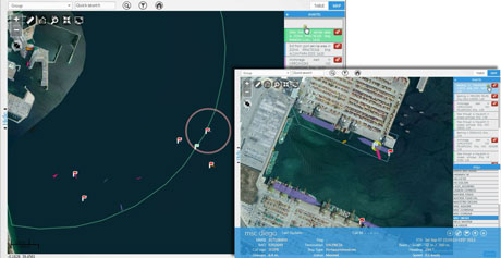
Working in parallel with the Docking Assist project, the Prodevelop geospatial research team extended the DSS module to a real time analysis engine based on spatial information (Geo-Decision Support System Module) to detect geospatial events. This technology has been included in a port management GIS module that automates relevant operational events, such as anchoring, berthing/unberthing, pilot and tug operations, bunkering, entry and exit of areas such as the port service area, waypoints or inner harbour, port exit with pending requested anchoring, etc. Detected events are published in real-time to a web Geographical Information System (GIS) application [3], available to all connected clients, as shown in Figure 2.

Figure 2: Event display to operators in the Posidonia Operations port system.
The event display includes an event list, warning icons, map warnings, location of events on the map, integration with operations register, and query of events. In order to process massive data streams coming from port and location sensors, in real time, the architecture makes use of the eXtreme Transaction Processing Platform (XTPP), message distribution middleware implementing Data Distribution Service (DDS) international OMG standard, Non-SQL repository, trajectory simplification, push notifications, eXtensible Messaging Presence Protocol (XMPP) IETF standard RFC 6120 and communication over WebSockets / Bidirectional-streams Over Synchronous HTTP (BOSH). The results to date are very encouraging: “Posidonia Operations” has been built upon the experience acquired in Docking Assist to provide a solution for managing the sea-side operations of vessels. The system has built in and comprehensive integration capability with security management systems, building management systems, SCADA, AIS/VTS systems, gate operating systems, terminal operating systems, port community and data interchange packages. In our research on the Docking Assist project we collaborated with several SMEs and research centres, namely ATEKNEA and ASCAMM (Spain), VTT (Finland), Port of Cork (Ireland), Marimatech (Denmark), Net Technologies (Greece) and Runcom Technologies (Israel). This research is also part of the strategic goals and recommendations for the EU Maritime Transport Policy until 2018 (IP/09/84), namely to ensure the long term performance of the European maritime transport system as a whole. Our work is partially supported by the Spanish MEC INNCORPORA-PTQ 2011 program. Links: References: Please contact:
http://www.dockingassist.eu
http://www.prodevelop.es
[1] IEEE 802.16 Working Group: “IEEE Standard for Local and Metropolitan Area Networks, Part 16: Air Interface for Fixed and Mobile Broadband Wireless Access Systems”, IEEE Standard 802.16-2009, May 2009
[2] L. Jiang et al: “DockingAssist: A novel vessel navigation system design based on WiMAX and DGNSS”, IEEE WPNC 2013, 1-6
[3] C. Joubert et al.: “Real-Time Visualization of MV/LV Energy Alarms on GIS Web Applications”, ERCIM News 2013(92).
Christophe Joubert
Prodevelop, Spain
E-mail:


