by Rob van der Mei, Maaike Bots and Frank Ottenhof
The use of in-car technology and real-time traffic information has been growing spectacularly over the past few years, and this growth is not likely to come to an end in the near future. However, despite their enormous benefits for our modern society, today’s navigation systems take into account important safety and environmental aspects to a limited extent at best. Moreover, the enormous diversity of the traffic-management applications and in-car systems available today often leads to contradictory routing advices and in many cases even to network instability. This raises the need for proper coordination between in-car navigation systems and traffic-control centres. CWI is developing data fusion models to estimate highway traffic. In the future these can be used as input for traffic forecasts.
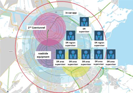
A powerful means to coordinate the wide variety of traffic data is to implement so-called digital road authorities (DRAs). A DRA is a virtual traffic manager that monitors the performance of the road network, and undertakes action when needed. DRAs are often implemented in large-scale, congested areas with many actuators and sensors. To use DRAs, the road network is typically sub-divided in regions, each of which is managed by a dedicated regional DRA. These regions, in turn, are subdivided in smaller areas. In this way, the road network can be seen as a virtual tree of national networks, regional networks, area networks, and so on. Similarly, these networks are supervised by digital road supervisors, digital road region supervisors and digital road area supervisors.
DRAs may be coupled to all measurement and control systems within their network, not only to roadside equipment (like sensors, ramp meters, cameras, radars, detection loops) and VRI’s, but also on in-car systems and applications. The DRA constantly monitors whether the requirements on reachability, safety, pollution and traffic throughput are met, and undertakes action when needed. To this end, the DRA for example may ask its neighbouring DRAs to decrease the influx of traffic. In case of overload in the whole network, it may occur that the neighbouring DRAs cannot help out. In that case, the DRA may contact a next higher layer DRA. And so on.
A successful example of DRA technology is the TrafficLink software [1] offered by Trinité Automation [2].
Societal importance and emergency situations
The proper use of DRA technology has far-going societal consequences. DRAs not only provide effective means to relieve road congestion and pollution, but may even save lives in emergency situations where every second counts. In the emergency medical services, like ambulance services, coupling dedicated sensor-based emergency apps to DRAs may (1) be an effective means to determine the fastest route to the emergency scene, by automatically switching to coordinated traffic light schedules in order to minimize travel time over a given route, (2) provide a means to detect road accidents more promptly, saving valuable time, and (3) enable car drivers on the same route to receive warning messages via their telephone or in-car system.
Prediction of traffic jams
The use of DRAs may also provide a way to predict, and hence take proper action to avoid, traffic jams. For example, by coupling weather forecasting services to DRAs, the occurrence of road congestion in specific areas may be predicted, and dynamic rerouting and coordination of traffic light schedules may be enforced to provide relief.
Research
In order to fully exploit the enormous possibilities offered by DRA to enhance mobility and save lives, a variety of research challenges are to be faced, including the following:
1. how to accurately estimate the traffic on highways and local roads for different types of data from different sources, like including detectors, cameras, Bluetooth- and GPS-devices,
2. how to accurately estimate travel times from A to B on the basis of the heterogeneity of data from different sources, and
3. how to proactively manage traffic on the basis of traffic forecasts to relieve/avoid congestion.
To cope with the heterogeneity of data sources, we are currently developing and validating quantitative models using techniques from data fusion in order estimate traffic and congestion on highways and local roads. These models serve as an input to travel-time models which, in turn, are used to develop dynamic congestion control mechanisms based on traffic forecasts.
Links:
[1] http://www.trafficlink.nl
[2] http://www.trinite.nl
Please contact:
Rob van der Mei
CWI, The Netherlands
Tel: +31 20 592 4129
E-mail:
Frank Ottenhof
Trinité Automation, The Netherlands
E-mail:

