


by Koray Kayabol
Many applications in remote sensing, varying from crop and forest classification to urban area extraction, use Synthetic Aperture Radar (SAR) image classification. As ERCIM Fellows, we have studied the classification of land covers for a year. Our results on the classification of water, land and urban areas can be used by city administrators and planners to automatically classify related land covers in order to control the development of the city, while preserving its resources like forests and waters.
The aim of image classification is to assign each pixel of the image to a class with regard to a feature space. These features can be the basic image properties as intensity and colours. Moreover, some more advance abstract image descriptors as textures can also be exploited as feature. Radar images are preferred in remote sensing because the acquisition of the images is not affected by light and weather conditions.
The developments in forming SAR images took place in the years 1950-1975 and the studies on processing and understanding SAR images started in the late 1970s. By the technological developments, we are now able to work with high resolution SAR images. For example, the images used in our studies have ground resolutions varying from 2.5 to 8.2 meters. The scope of our work is high resolution SAR image classification. As a feature, we use the amplitudes of the SAR images. As a model density for SAR image amplitudes, we use the Nakagami density, since it is a basic multi-look amplitude model for SAR images. Multi-look SAR images are formed by scanning the same region multiple times and consequently have less noise than the single-look SAR images. Beside the amplitudes, we must take into consideration the spatial neighborhood of the pixels to obtain some smooth and connected components in the class label map. We introduce the spatial interactions adopting the Multinomial Logistic model to obtain a smooth classification map.
In this work, we follow the model based classification approach to reach a novel unsupervised classification algorithm for SAR images. The Finite Mixture Model (FMM) is a suitable statistical model to represent the SAR image histogram and to perform a model based classification. Fitting a mixture model to some data can be realized by using the Expectation-Maximization algorithm. We use a computationally less expensive version of the EM algorithm, namely Classification EM (CEM), for both parameter estimation and classification, using the advantage of categorical random variables. Determining the necessary number of classes and initialization are some drawbacks of the EM type algorithms. First time in this study, we combine hierarchical agglomeration, CEM and a model order selection criterion to get rid of the drawbacks of CEM in order to obtain an unsupervised SAR image classification algorithm. In this way, we are able to determine the necessary number of land covers in a given area. We start the CEM algorithm with a large number of classes and then reduce the number of classes iteratively by merging the weakest class in probability to the one that is most similar to it with respect to a distance measure. Figure 1 demonstrates the algorithm where a SAR image is classified to three regions namely, urban, land and water areas.
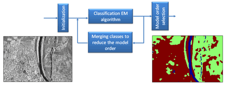
Figure 1: Region based classification of a TerraSAR-X image by hierarchical agglomeration based unsupervised algorithm. The TerraSAR-X image was acquired over the city of Rosenheim in Germany.
This work started in November 2010 and major parts were completed in the Ariana/Ayin research group at INRIA, France, lead by Josiane Zerubia. Koray Kayabol carried out this work during the tenure of an ERCIM ‘Alain Bensoussan’ Postdoctoral Fellowship Programme. He is currently pursuing his works in the Probability and Stochastic Networks (PNA2) group at CWI, The Netherlands with Marie-Colette van Lieshout as part of the ERCIM MUSCLE Working Group. We presented this research during the MUSCLE International Workshop on Computational Intelligence for Multimedia Understanding held in Pisa, Italy, organized by the Working Group. The study is planned to be finalized in April 2012. The Italian Space Agency (ASI) provided the COSMO-SkyMed images. The TerraSAR-X images are provided by Astrium Services (Infoterra) from http://www.infoterra.de/. The papers written during the study can be found in the links below.
Links:
http://www-sop.inria.fr/ariana/en/lequipe.php?name=Kayabol
http://hal.archives-ouvertes.fr/hal-00612491/fr/
http://www.cwi.nl/research-groups/Probability-and-Stochastic-Networks
http://repository.cwi.nl/search/searchrepository.php?cwi=2457
http://muscle.isti.cnr.it/pisaworkshop2011/index.html
Please contact:
Koray Kayabol, CWI, The Netherlands
E-mail:
Josiane Zerubia, Inria, France
E-mail:
