by Salvatore Aronica, Massimo Cossentino, Carmelo Lodato, Salvatore Lopes, Umberto Maniscalco.
Information and communications technologies promise to have a significant impact on safety at sea. This is particularly true for smaller ships and boats that rarely have active on board safety systems. We are currently developing a system for computer-aided maritime search and rescue operations within the ICT-E3 Project (ICT excellence programme of Western Sicily funded by the Sicilian Regional Government).
A successful conclusion of a maritime search and rescue (SAR) operation depends on several factors. Some, like the weather and sea conditions, are uncontrollable; others can be optimized and made more effective by the employment of information and communications technologies. A system able to localize a vessel in trouble and to define the most efficient plan for search and rescue activities is of great importance for safety at sea.
The first step in building such a system is an accurate localization of vessels in trouble. Normally, the last known position (LKP) of a vessel is communicated to the rescuers by the people on board. This apparently simple action can become extremely difficult with adverse weather and sea conditions. To add to the difficulty, those on board may only know their positions approximately or, at worst, not at all. The vessel may not be equipped with a global positioning system or even a suitable compass to obtain at least some bearings. Thus the localization provided by the people on board of a vessel in trouble may generate imprecise or useless information.
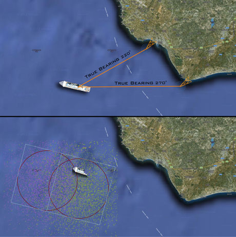
However, if a rescue request is received by radio, localization can be achieved in a few seconds with good precision and without any specific information communicated by the vessel in trouble. As a rule, a couple (or a net) of radio direction finders (RDFs) can detect the direction of an incoming radio signal via voice on VHF channel 16 or by digital selective calling (a distress signal on VHF). Hence, automatic localization is possible via a simple triangulation if at least two or more RDFs, placed in different points, get a bearing from a radio signal. If the people awaiting rescue continue to communicate via radio, our system can track the vessel by successive localizations. With an accurate localization of the vessel, search and rescue operations (SAROPs) have a higher probability of success.
SAROPs are regulated at the international level by a set of standard procedures defined and described in the IAMSAR volume II (International Aeronautical and Maritime Search and Rescue). IAMSAR procedures require many meteorological parameters, they employ many data tables and curve plots in order to evaluate the datum (a geographic point, line or area used as reference in the search planning). However, such procedures involve several complex computations and require a lot of valuable time thus delaying the start of a SAROP.

Figure 1: Upper side: a simple scenario with two stations detecting an emergency call.
Lower side: datum, search area and probability distribution obtained by the Monte Carlo simulation.
The use of a computer system implementing all the procedures involved in SAROPs can reduce errors and the time needed to define a SAR plan; it can also improve on the probability of success of the rescue mission.
IAMSAR procedures were originally developed for manual calculation and they do not include the support for a computer implementation. Hence, they avoid the adoption of complex and effective algorithms for defining the search action plan; such algorithms are a viable solution when the support of a computer is available. For the same reason, the IAMSAR manual only suggests two simple search paths for the navigation of SAR units; furthermore, the handling and the allocation of these units over the search area, is quite rigid.
Starting from these considerations, we have developed an enhanced implementation of IAMSAR procedures and have integrated it with the automatic localization system outlined above. An enhanced statistical processing method (the Monte Carlo simulation technique) has been introduced in this implementation. It determines the search area instead of the prefixed probability maps suggested by the IAMSAR manual. Crucial data, like wind force, state of the sea and water current models from SOAP messages, can also be integrated. The system includes a database in which all SAR units at disposal of a Coast Guard Station are stored with details of their salient features. A friendly graphic user interface has been designed, where several graphic layers of information can be overlaid or hidden in visualization.
Other significant and innovative extensions of the IAMSAR procedures have been carried out during the development of the ICT-E3 project, and are now subject to a patent application. We wish to acknowledge the collaboration with the personnel of the Mazara del Vallo Coast Guard Station, their invaluable help and stimulating suggestions have been fundamental to the success of the activity.
Link: http://ceur-ws.org/Vol-621/paper21.pdf
Please contact:
Massimo Cossentino, Carmelo Lodato, Salvatore Lopes, Umberto Maniscalco
ICAR-CNR, Italy
E-mail:
Salvatore Aronica, IAMC-CNR, Italy
E-mail:


