by Andrew Woolf
An explosion in the instrumentation of our environment using sensors of all descriptions is driving the development of infrastructure to manage the wealth of information they collect. The Sensor Web aims to simplify the publication of, and access to, sensor resources, just as the World Wide Web has done for documents. And, as with the WWW, the Sensor Web relies on new information and communication standards for structuring sensor information and its exchange.
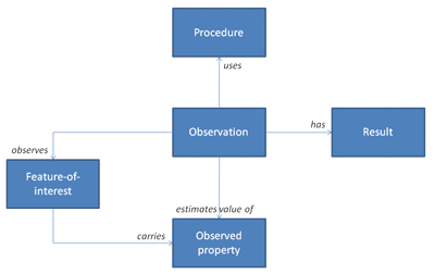
At the heart of these new standards is a conceptual model for Observations and Measurements (O&M, [OGC 07-022r1, OGC 07-002r3]). It says simply that an Observation is an action whose Result is an estimate of the value of some Property of a Feature-of-interest, obtained using a specified Procedure (See Figure 1). Each of these core O&M information classes may be extended to specific sensor applications (see "Example: Marine Science Observation" below).
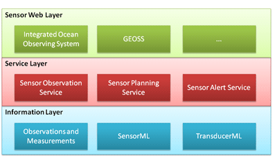
The abstract O&M model may be applied across the spectrum of sensor applications and deployments, and provides a framework for building exchange standards and service interfaces for accessing sensor data and contextual information (Figure 2: The Sensor Web standards stack.). For example, the Sensor Observation Service (SOS, [OGC 06-009r6]) provides a Web service interface for retrieving filtered observations or related information (feature-of-interest, sensor parameters, observation results). Individual sensor observations may be aggregated within one service into combined 'observation offerings' and multiple services may be federated into single access points. The Sensor Model Language (SensorML, [OGC 07-000]) is an XML language for describing observation procedures and sensor types. Other related standards include the Transducer Markup Language (TML, [OGC 06-010r6]) for transducers and transducer systems, the Sensor Planning Service (SPS, [OGC 07-014r3]) for tasking and scheduling observation requests with sensor systems (eg by satellite remote-sensing instruments), and the Sensor Alert Service (SAS, [OGC 06-028r3]) for setting up notification subscriptions for specific sensor events.
These new standards are being developed by the Open Geospatial Consortium (OGC), a non-profit de facto international standards body for geographic information. OGC members span government, academia and industry. Organizations contributing to the O&M specification include CSIRO (AU) as editor, Geoscience Australia (AU), University of Alabama in Huntsville (US), Image Matters LLC (US), Washington University (US), Science and Technology Facilities Council (UK), SeiCorp Inc. (US), Galdos Systems Inc. (CA), Geospatial Research & Consulting (DE), PCI Geomatics (CA), and Texas A&M University (US).
Research undertaken through global collaborations of experts, often in the context of coordinated international engineering testbed activities (the OGC Web Service Initiatives) accelerates the development of interoperability standards and protocols. With sufficient maturity, these specifications will be proposed for de jure standardization through the International Organization for Standardization (ISO).
The O&M conceptual model has been substantially developed since 2002 through such initiatives (OWS-1.2 and OWS-3). It was finally approved in 2008 for Version One publication by OGC, and is being progressed as a new ISO standard 19156 (see links below).
A growing awareness of the importance of environmental monitoring for the health of our planet is leading to the development of large-scale infrastructures that transcend national boundaries. Through a ten-year implementation plan, the Group on Earth Observations (a grouping of 76 national governments and other international organizations) aims to integrate existing observation networks into a Global Earth Observation System of Systems (GEOSS) to achieve comprehensive, coordinated and sustained observation of the Earth system.
Within Europe, a recent Directive (2007/2/EC) will establish the 'Infrastructure for Spatial Information in Europe' (INSPIRE) to integrate environmental data across all member states. The 'Kopernikus' partnership between the European Commission and the European Space Agency will establish core operational services (eg ocean forecasting, landcover monitoring, emergency response) for the global environment and civil security. These three global-scale initiatives all require standard information models and network services for integrating sensor data - both in situ and remotely sensed (spaceborne and airborne).
An underlying abstract architectural approach is used to develop Sensor Web standards. The Reference Model for Open Distributed Processing (RM-ODP, [ISO/IEC 10746]) factors a distributed system like a Sensor Web into five complementary viewpoints: enterprise (roles, scope and policies of the system), information (semantics of information and information processing), computational (service interfaces), engineering (component distribution across nodes) and technology (implementation choices). Against this model, O&M provides the information viewpoint, while service standards like SOS and SPS provide the computational viewpoint.
Within the broader context of ICT innovation, Sensor Web standards build on key W3C specifications (XML, Web services). There is a growing move towards richer semantics, for describing observed properties and their relationships; for instance, ISO 19150 is a new standard for the use of ontologies with geographic information. An important principle is the decomposition of domains of governance identifying responsible parties with a remit for managing agreed vocabularies and concepts on behalf of a community of interest (eg definitions of particular sensor systems and observables). This is required in order to facilitate reuse of models and enhance interoperability.
While much of the Sensor Web standardization work has so far been developmental, there are beginning to emerge practical demonstrations of their effectiveness. Demonstrators like the US-based OpenIOOS testbed for an Integrated Ocean Observing System and projects like the European 'Sensors Anywhere' (SANY) FP6 Integrated Project are validating the application of these standards in real Sensor Web applications.
Example: Marine Science Observation
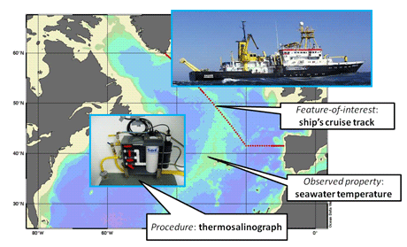
The SOS GetObservation operation is used to retrieve the entire observation and its context; DescribeSensor will return thermosalinograph details; GetFeatureOfInterest provides details of the cruise track; while GetResult returns just numerical temperature values.
Links:
http://www.opengeospatial.org/
http://www.earthobservations.org
http://www.opengeospatial.org/ogc/markets-technologies/swe
http://www.isotc211.org/
http://inspire.jrc.ec.europa.eu/
http://ec.europa.eu/gmes/index_en.htm
http://www.sany-ip.eu
Please contact:
Andrew Woolf
e-Science Centre, STFC Rutherford Appleton Laboratory, UK
Tel: +44 1235 778027
E-mail: Andrew.Woolf![]() stfc.ac.uk
stfc.ac.uk

