by Thomas Usländer and Kym Watson
Working towards 'plug and measure' in sensor networks for environmental monitoring with Open Geospatial Consortium (OGC) standards, the SANY (Sensors Anywhere) project specifies an architecture for all kinds of fixed and moving sensors. This will allow both seamless plug-and-measure capability for sensors in the field, and sharing of information between sensor networks.
The SANY project focuses on interoperability of in-situ sensors and sensor networks. This is done using both the standards and the on-going work of the OGC (in particular the Sensor Web Enablement suite of standards), OASIS (Organization for the Advancement of Structured Information Standards) and W3C. The SANY sensor service architecture provides a quick and cost-efficient way to reuse data from sensor and data sources that are currently incompatible. Data sources can include live sensor data, databases of archived data and model-based calculations.
The sensor service architecture and the service specifications have been made publicly available on the SANY project server, while the SANY specifications and best practice experience have been contributed to the OGC standardization work. The results are being tested in three innovative risk management applications covering the areas of air quality, marine risks and geo-hazards.
The Fraunhofer Institute for Information and Data Processing (IITB) has realized a testbed for sensors and services in order to trial the architecture and specifications. At the sensor network level, the ad hoc wireless ZigBee network is complemented by simulated sensor nodes, which measure properties such as temperature, humidity, illuminance and acceleration. The testbed is designed for experiments in a wide range of scenarios and scales, such as mobile sensors traversing several networks. The simulation is implemented as an application in LabVIEW (National Instruments), which has the additional task of configuring the ZigBee nodes. New sensor nodes (either real or simulated) are recognized automatically and registered in one of three OGC Sensor Observation Servers (SOS). The sensor values are then inserted into an SOS as they arise by measurement or simulation. The available network resources (observed features, sensors, services) are registered in a catalogue server along with metadata to support resource discovery by client applications. Clients can find, for example, information sources for a given region and observable phenomenon of interest.
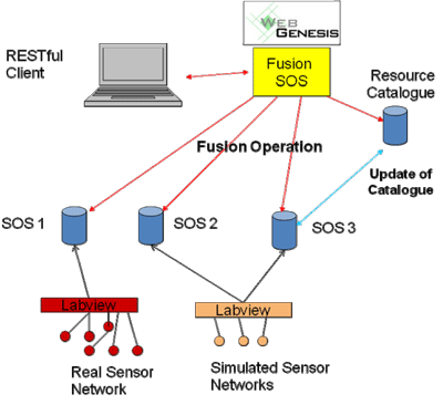
Fraunhofer has produced in the testbed a special SOS known as a Fusion SOS, which is able to aggregate or fuse sensor data from several SOSs. The Fusion SOS queries the catalogue for available SOSs of the required type and then conducts a selected procedure to produce a spatial or spatio-temporal interpolation. The interpolation result is a so-called coverage, a function defined on a space-time grid of sampling points. The procedure takes the inaccuracy of the raw sensor data into account. The spatio-temporal uncertainty of the fusion result is specified using uncertML, an XML schema developed by the INTAMAP (Interoperability and Automated Mapping) project to describe the statistics of uncertain data. As with the underlying sensors, the fusion procedure is described with the OGC sensor model language SensorML. In this way, the fusion procedure can be treated as a sensor, but with the important characteristic that its result is a coverage. The coverage can be visualized using a Map & Diagram service from the SANY partner ETH Zürich.
The procedures developed to date are variants of the Bayesian Maximum Entropy method that is able to consider soft sensor data (eg where the sensor value lies in an interval) and additional phenomenological knowledge on the relationships between observed properties. If additional sensors or SOSs enter the testbed, the Fusion SOS discovers these new resources with the aid of the catalogue and incorporates the new data sources automatically into the fusion procedure. The self-describing information plays an essential role in this plug-and-measure capability.
The Fusion SOS is implemented on the platform WebGenesis, an information management server from Fraunhofer IITB. The information management server contains the information categories features of interest (sampling grids), procedures and results with associated metadata to support searching. The intermediate files produced by the fusion procedure are uploaded together with the fusion result to the WebGenesis information management server. This ensures a reproducible trace of the processing steps.
On-going work in the testbed involves the use of RESTful Web services to provide representations of the network resources and the development of model-based fusion methods. SANY (Sensors Anywhere) is an FP6 Integrated Project co-funded by the European Commission within the Thematic Priority 'Information Society Technologies' in the area of ICT for environmental risk management. SANY is a three-year project that started in September 2006 and has now completed two of three development cycles. The SANY consortium is composed of sixteen partners from eight countries. It includes the two research organizations Austrian Research Centers (coordinator of the consortium) and Fraunhofer, six companies, three universities, four public authorities and the Open Geospatial Consortium Europe (OGC).
Links:
http://www.sany-ip.eu/
http://www.opengeospatial.org/
Please contact:
Kym Watson
Fraunhofer Institute IITB, Germany
Tel: +49 721 6091 486
E-mail: kym.watson![]() iitb.fraunhofer.de
iitb.fraunhofer.de

