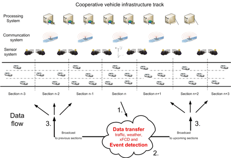
Intelligent transportation systems of the future will take advantage of rapid developments in information and communication technology. Their aim is to make the movement of traffic safer, more efficient, more comfortable and cleaner by linking relevant traffic information coming from the vehicles (eg navigation, in-vehicle data systems) with that from roadside sensor systems (eg traffic flow, density, weather etc). So-called 'cooperative vehicle infrastructure systems' should promote the safe and optimal use of road network capacity and a better response to incidents and hazards, through increased and up-to-date information about vehicles, their location, and road conditions in the whole road network.

The cooperative vehicle infrastructure system used in this project had a total length of six kilometres and was installed on part of the Austrian freeway A2. The test track was equipped with several wireless access points, enabling a seamless communication zone for bidirectional vehicle-to-infrastructure communication.
The collection of traffic data was performed with a camera system consisting of sixteen video cameras along eight cross-sections. From the camera images, microscopic traffic data such as velocity, type of vehicle (passenger car/HGV) and appropriate lane are derived by image-processing software. Out of this, macroscopic values such as aggregated traffic flow and average velocities for each section and lane are calculated.
Weather data was collected by a weather station installed on the centre of the test track. The station was equipped with both standard sensors (eg temperature, precipitation type and intensity, wind speed, humidity etc) and additional sensors for precise safety evaluation (eg integrated water film thickness, visibility). Both traffic and weather information were collected through a time-triggered central server system and were prepared for further data processing there.
On the infrastructure side, a complete road surface and road bed measurement was performed with a specially equipped measurement vehicle (RoadSTAR), which measured safety-related parameters like skid resistance, transverse evenness, longitudinal profile, roughness, texture and road geometry in a standardized manner.
In order for bidirectional cooperative vehicle-infrastructure interaction to work, it is necessary both to gather information from vehicles driving on the section and to transfer relevant events from them. The basic idea comes from the classical approach of floating car data, where vehicles regularly transmit their positions, which can then be used to generate traffic information (travel times, velocities, level of service).
Within the project, an in-car application was developed that processed vehicle data and detected the following events from it: accident, emergency braking, loss of traction, rain, wet surface and warning light activation. Together with the GPS position, the event code was transmitted to the central system in real time. For demonstration purposes, substitute signals like headlight activation or other 'harmless' events were used to simulate the events mentioned above.
The data measured by the traffic and weather sensors was transferred through a fibre optic communication network to the processing servers. The processing servers received the time-based (weather, traffic) and event-based data (extended floating car data, xFCD) and calculated a recommended adaptive velocity for each lane and section along the track. The algorithms developed for the calculation of the adaptive velocity were also a subject of the research project.
The aim of the project was to demonstrate traffic safety applications that run within a cooperative vehicle-infrastructure system. A number of test scenarios were run during the project in which incidents on the infrastructure side were simulated by manually changing the traffic or weather values. The data transmission time between the infrastructure and vehicles was under two seconds, which is a satisfying value at a prototype (demonstration) level. The uploading of extended floating car data events was also demonstrated successfully by sending (simulated) in-vehicle events (eg 'accident'). The information was processed and sent back to the relevant section (and vehicles) within two seconds.
At the beginning of the project, an accident analysis for this specific part of the freeway was performed. This showed that almost 50% of accidents recorded were due to cars straying out of their lanes due to unsuitable velocities, while another 20% were rear-end collisions. Both these types of accident can be avoided by a warning and recommendation system, and a significant reduction in the number of accidents and their severity can be expected in the future.
Link:
http://www.arsenal.ac.at
Please contact:
Kashif Din
Österreichisches Forschungs- und Prüfzentrum Arsenal GmbH, Austria
Tel: +43 50550 6639
E-mail: kashif.din![]() arsenal.ac.at
arsenal.ac.at


