


Hydrometeorological science has made strong progress over the last decade as new modelling tools, post processing methodologies and observational data have become available. The goal of the DRIHMS project is to promote collaboration between the hydrometeorological and the GRID research communities in order to further advance the state-of-the-art.
The DRIHMS (Distributed Research Infrastructure for Hydro-Meteorology Study) project is an EU support action on the use of Grid, High Performance Computing (HPC) and Information and Communication Technologies (ICT) in the field of HydroMeteo Research (HMR). Its goals are:
- to promote the GRID paradigm within the European hydrometeorological research community
- to boost European research excellence and competitiveness in hydrometeorological and Grid research by bridging the gaps between these two communities.
DRIHMS is conducted by a consortium of hydrometeorology (DLR and CIMA) and ICT (LMU and IMATI) research centres that integrate complementary multidisciplinary know-how enabling the use of Grid-related technologies in the area of hydrometeorological science.
The prediction of floods and other hydrometeorological events relies on hydrological and meteorological forecast models that describe the hydrological cycle in the atmosphere. These predictions are based on observational measurements, for example of rainfall and river flow. In recent years, the quantity and complexity of the tools and data sets have increased dramatically for three reasons:
- the increasing availability of remote sensing observations from satellites and ground-based radars that provide complete three-dimensional coverage of the atmospheric and land surface state
- the development of forecasting methods that combine multiple numerical weather prediction and hydrological models through stochastic downscaling techniques to quantify the uncertainty in the forecast, multiplying the computational costs
- increasing recognition of the need to understand the entire forecasting chain, from observations through to civil defence response, resulting in complex workflows able to combine different data sets, models and expertise in a flexible manner.
HydroMeteo Research is closely linked to operational forecasting. Researchers rely on data archives maintained by operational agencies and increasingly make use of operational modelling tools. However these data sets and tools are mainly the property of national agencies and are not often easily obtainable at a European level. A second major source of material for research is the existence of ad hoc collections of data from field campaigns and experimental instruments. However, the heterogeneity of the data, and of the metadata describing it, makes it difficult for scientists to locate and exploit the data relevant for their task.
Similarly, the scattering of hydrometeorological data tools among national and ad hoc collections is a substantial barrier to progress in research. On the one hand, weather systems freely cross national boundaries, rendering national archives of limited use. This has long been recognised in meteorology, and indeed the World Meteorological Organisation (WMO) effectively coordinates the international exchange of much meteorological data. Unfortunately this does not include much of the high resolution data required for hydrometeorological research. Figure 1 shows the key elements in an HMR forecasting chain; they are all highly demanding from the data storage and high performance computing standpoints.
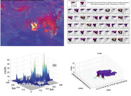
Figure 1: The HMR forecasting chain: satellite data (top left), meteorological ensemble probabilistic system (top right), stochastic downscaling (bottom left) and high-resolution meteorological modelling (bottom right).
Similarly, the scattering of hydrometeorological data tools among national and ad hoc collections is a substantial barrier to research progress. On the one hand, weather systems freely cross national boundaries, rendering national archives of limited use. This has long been recognised in meteorology, and indeed the World Meteorological Organisation (WMO) effectively coordinates the international exchange of much meteorological data. Unfortunately this does not include much of the high resolution data required for hydrometeorological research.
The need for large data sets and complex numerical models is not unique to hydrometeorological research. Under the name of e-science, a number of initiatives have been undertaken to provide the necessary ICT infrastructure, including EGEE (Enabling Grids for E-sciencE), SEE-GRID-SCI (South East Europe -GRID e-Infrastructure for regional e-Science), and the German C3-Grid.
DRIHMS aims at identifying the key areas for hydrometeorological research which require a network-based and distributed approach in terms of data and software sharing. Project activities focus on discussing, defining and communicating the requirements for the porting and deployment of state-of-the-art research applications and tools over heterogeneous Grid middleware.
The key element of DRIHMS is the organization of a set of networking activities (including web based questionnaires, invitation-only workshops and open conferences), involving both hydrometeorologists and Grid experts, aimed at overcoming current limitations in the sharing of tools and knowhow in the European HMR community. The networking activities will facilitate the development of a pool of common knowledge from the knowledge currently available and hopefully derive new knowledge from last generation hydrometeorological processes observing/modelling systems.
DRIHMS is currently surveying the ICT and HMR communities in order to collect the requirements of the HydroMeteo research community and to assess which ICT tools can satisfy them. So far almost 300 questionnaires have been completed by scientists from all over the world, but we would like to request the assistance of all those interested in this initiative to spare a few minutes to complete the questionnaires online at the link below.
Link: http://www.drihms.eu/survey
Please contact:
Alfonso Quarati, IMATI-CNR, Italy
E-mail:
